
Meteorology Today Second Canadian Edition
Earth and Atmospheric Sciences
At its simplest, a thunderstorm is a storm characterized by the presence of lightning and its acoustic effect on the Earth’s atmosphere, known as thunder. They are fueled by the rapid upward movement of warm, moist air, a process known as convection.
1. The Ingredients of a Thunderstorm
To cook up a thunderstorm, the atmosphere needs three specific ingredients:
- Moisture: To form clouds and rain.
- Instability: Warm air that is less dense than the surrounding environment, allowing it to rise rapidly.
- A Lift Mechanism: Something to push the air upward, such as a cold front, a mountain range, or intense heating from the sun.
As the warm air rises (the updraft), it cools and condenses into water droplets, forming a cumulonimbus cloud. When the droplets become heavy enough, they fall as precipitation, dragging cold air down with them (the downdraft).
2. The Transition: From Storm to Tornado

While many thunderstorms occur daily, only a small fraction—usually Supercells—produce tornadoes. Supercells are unique because they contain a mesocyclone, a persistent, rotating updraft.
Step A: Wind Shear
The process begins with vertical wind shear. This happens when wind speed or direction changes significantly with altitude. This difference in wind creates a “rolling” tube of air that sits horizontally in the lower atmosphere.
Step B: Tilting
When a strong updraft from a developing thunderstorm hits this horizontal rolling tube, it tilts the rotation from horizontal to vertical. This creates a rotating column of air within the storm itself.
Step C: Stretching and Concentration
As the mesocyclone rotates, it can be “stretched” by the updraft. Just like an ice skater spins faster when they pull their arms in, the narrowing of this rotating column increases its wind speed.
Step D: The Touchdown
If a downdraft of cool, moist air (the Rear Flank Downdraft) wraps around the mesocyclone and pushes it toward the ground, the rotation can intensify into a narrow funnel. Once that funnel makes contact with the earth’s surface, it is officially classified as a tornado.
What are thunderstorms?
At its most basic level, a thunderstorm is a storm characterized by the presence of lightning and its acoustic effect on the Earth’s atmosphere, known as thunder. They are fueled by the rapid upward movement of warm, moist air—a process called convection.
The Three Essential Ingredients
To “cook” a thunderstorm, the atmosphere needs three specific components:
- Moisture: This provides the fuel for the storm. When water vapor condenses into liquid droplets, it releases latent heat, which keeps the air inside the storm warmer than the surrounding air.
- Instability: The atmosphere is “unstable” when a pocket of warm air is less dense than the air above it. Like a hot air balloon, this air wants to rise.
- A Lift Mechanism: Something must push that warm, moist air upward to start the process. Common “lifters” include cold fronts, mountains, or intense solar heating of the ground.
The Life Cycle of a Thunderstorm
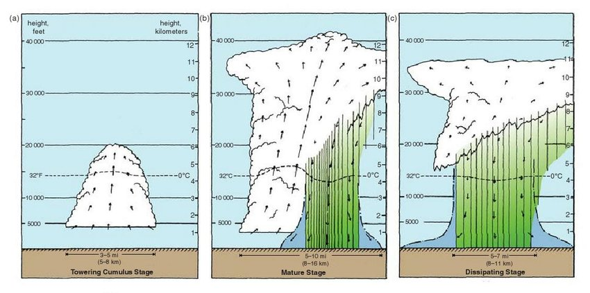
A typical thunderstorm (often called a “cell”) goes through three distinct stages:
1. The Towering Cumulus Stage
The storm begins as a plume of warm, moist air rising in a strong updraft. As the air rises and cools, it condenses into a billowing white cloud. At this stage, there is no rain and no lightning, but the cloud is growing rapidly.
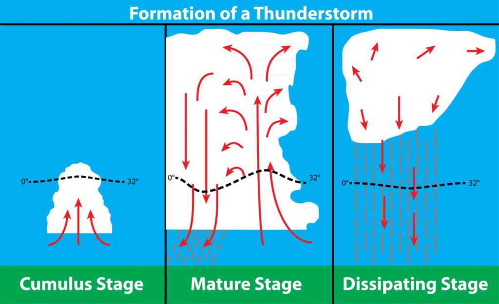
2. The Mature Stage
This is the storm’s most intense phase. The updraft continues to feed the storm, but now water droplets and ice crystals have become heavy enough to fall. As they fall, they drag cool air down with them, creating a downdraft.
- Lightning and Thunder: The friction between rising ice crystals and falling slush (graupel) creates a static charge, leading to lightning.
- The Anvil: If the storm hits the top of the troposphere, the updraft spreads out horizontally, creating the classic “flat top” or anvil shape.
3. The Dissipating Stage
Eventually, the downdraft becomes so strong that it “chokes off” the updraft. Without a supply of warm, moist air from the ground, the storm loses its fuel source. The rain lightens, and the cloud begins to evaporate and fray at the edges.
Severe Thunderstorms & Tornadoes
While most thunderstorms are “pulse” storms that last less than an hour, some become Supercells. These are highly organized storms with a rotating updraft called a mesocyclone.
If the rotation in a supercell is tightened and stretched by a combination of strong updrafts and sinking air (the Rear Flank Downdraft), it can reach the ground as a tornado.
What are ordinary cell thunderstorms?
An ordinary cell thunderstorm, often called a “pulse” thunderstorm, is the most common and generally the weakest type of thunderstorm. Unlike supercells that can last for hours and produce tornadoes, an ordinary cell usually completes its entire life cycle in about 30 to 60 minutes.
These storms typically form in environments with low vertical wind shear (where wind speed and direction don’t change much as you go higher in the sky). Because of this lack of shear, the storm essentially “chokes” itself out.
The Three Stages of Development
1. The Cumulus Stage
The storm begins with a warm, moist updraft. As the air rises, it cools and condenses into a billowing cumulus cloud. At this point, there is no rain or lightning—just a growing tower of white, puffy clouds.
2. The Mature Stage
This is the peak of the storm’s intensity. Precipitation begins to fall, dragging cold air down with it to create a downdraft.
- The Conflict: During this stage, both an updraft and a downdraft exist side-by-side.
- The Result: You’ll see heavy rain, occasional small hail, and lightning. The top of the cloud may spread out into an anvil shape as it hits the top of the troposphere.
3. The Dissipating Stage
Because there is very little wind shear to tilt the storm, the downdraft eventually falls directly into the path of the updraft. This cuts off the supply of warm, rising air (the storm’s “fuel”).
- The End: The cloud begins to look “wispy” or frayed as it evaporates, and the rain lightens until the cell disappears completely.
Why They Rarely Produce Severe Weather
Since ordinary cells are short-lived and lack a rotating updraft (mesocyclone), they rarely produce the destructive winds or large tornadoes associated with more complex systems. However, they can still produce:
- Frequent Lightning: Which is always a hazard.
- Microbursts: Intense, localized downdrafts that can cause sudden wind damage at the ground.
- Heavy Rainfall: Which can lead to brief localized flooding.
In areas like the Canadian Prairies, these are the “pop-up” storms you often see on a hot July afternoon that seem to appear out of nowhere and vanish just as quickly.
What are multicell thunderstorms?
A multicell thunderstorm is a cluster of individual storm cells in various stages of development that act as a single unit. While an ordinary cell might last 30 minutes, a multicell cluster can persist for several hours because it is constantly “regenerating” new cells.
How They Differ from Ordinary Cells
In an ordinary cell, the downdraft eventually falls directly into the updraft and “chokes” the storm. In a multicell system, moderate wind shear tilts the storm. This separation allows the cool downdraft to hit the ground and spread out without immediately killing the warm updraft.
The Mechanism: The “Gust Front”
The key to a multicell storm’s longevity is the gust front (or outflow boundary).
- The Downdraft: As rain and cool air sink, they hit the ground and spread out like a ripple in a pond.
- The Lift: This leading edge of cold air acts like a “miniature cold front.”
- New Growth: As the gust front pushes forward, it forces the warm, unstable air in front of it to rise. This lift triggers the birth of a new “daughter” cell.
Common Characteristics
Multicell storms are responsible for much of the “severe” weather we experience during the summer months in the Prairies. They often manifest in two ways:
- Multicell Clusters: A disorganized “clump” of storms. As you watch the radar, you’ll see old cells fading on one side while bright new spots appear on the other.
- Squall Lines (Multicell Lines): A long, narrow line of active thunderstorms. These are often preceded by a dramatic shelf cloud and can produce intense “straight-line” winds.
What to Expect
While they aren’t as likely to produce violent tornadoes as supercells, multicell systems are the primary culprits for:
- Hail: Because the system lasts longer, there is more time for hail to grow.
- Flash Flooding: Since multiple cells may pass over the same area (a process called “training”), rainfall totals can add up quickly.
- Damaging Winds: The combined downdrafts can create powerful gusts over a wide area.
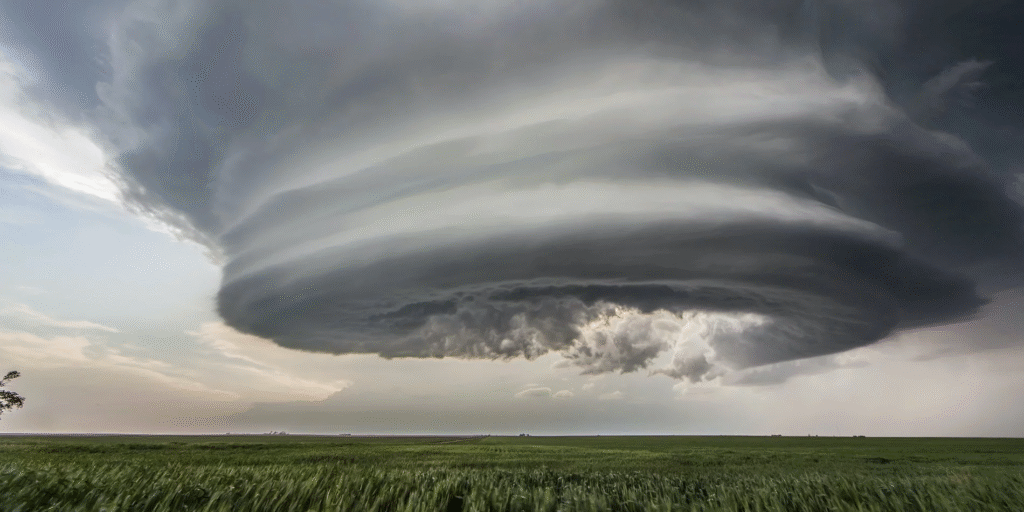
What are supercell thunderstorms?
A supercell is the most powerful and organized type of thunderstorm. While they are the least common type of storm, they are responsible for the vast majority of severe weather events, including giant hail and nearly all significant tornadoes.
The defining characteristic of a supercell is a mesocyclone: a deep, persistently rotating updraft.
Why Supercells are Unique
In ordinary or multicell storms, the updraft and downdraft often interfere with each other. In a supercell, high vertical wind shear (significant changes in wind speed and direction with height) creates a highly organized internal structure.
- Rotation: The wind shear creates a horizontal “rolling” effect in the lower atmosphere, which the storm’s powerful updraft then tilts into a vertical position.
- Separation: Because the storm is tilted, the precipitation (and the cold downdraft it creates) falls away from the updraft. This prevents the storm from “choking” itself out, allowing it to maintain its intensity for hours.
Visual Features of a Supercell
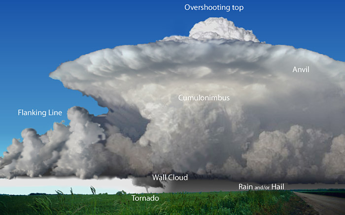
If you are spotting a storm in the open plains, a supercell often displays distinct, dramatic features:
- The Wall Cloud: A localized lowering of the rain-free cloud base. This is the area where the rotating updraft is strongest. If a tornado forms, it will typically descend from this wall cloud.
- The Inflow Band (Beaver Tail): A “tail” of clouds that flows into the storm, representing the warm, moist air being sucked into the updraft.
- The Overshooting Top: A dome-like bulge that breaks through the flat “anvil” top of the storm. This is a sign of an incredibly powerful updraft punching into the lower stratosphere.
- The Vault (BWER): On radar, these storms often show a “Bounded Weak Echo Region,” where the updraft is so strong it sweeps rain and hail upward before they can even be detected.
Associated Hazards
Supercells are considered “long-lived” and can travel hundreds of kilometers across provinces or states. They almost always produce:
- Extreme Hail: Often larger than golf balls or even grapefruits.
- Powerful Winds: Downbursts and straight-line winds exceeding 100 km/h.
- Tornadoes: While not every supercell produces a tornado, nearly all violent (EF-4 or EF-5) tornadoes come from supercells.
What is the relationship between thunderstorms and the dryline?
In the context of the Canadian Prairies, the dryline is a critical but often subtle boundary that acts as a primary trigger for severe thunderstorms.
What is the Canadian Dryline?
The dryline is a boundary separating two distinct air masses:
- To the West: Hot, dry air descending from the Rockies (often originating from the Desert Southwest of the U.S.).
- To the East: Warm, moist air (often flowing north from the Gulf of Mexico or evaporated from local crops and soil).
While a cold front is defined by a change in temperature, the dryline is defined by a sharp change in dew point (moisture).
The Relationship: How it Triggers Storms
The dryline acts as a “lifting mechanism” for thunderstorms through two main processes:
1. Density Differences
Surprisingly, moist air is actually less dense than dry air at the same temperature. As the dry air pushes eastward, it acts like a wedge, sliding under the lighter, moist air and forcing it upward. This upward motion is the “spark” needed to start convection.
2. Surface Convergence
Winds behind the dryline usually blow from the west or southwest, while winds ahead of it blow from the south or southeast. These winds “crash” into each other at the dryline (convergence), having nowhere to go but up.
Local Impact: The Alberta “Corridor”
In Alberta, the dryline often sets up along the foothills or roughly parallel to Highway 2 (the Edmonton-Calgary corridor).
- Dryline “Bulges”: Sometimes the dry air pushes forward in a “bulge.” These areas are high-risk zones where the most intense supercells are likely to form.
- Timing: The dryline typically moves east during the afternoon as the sun heats the ground, which is why we often see severe storms “fire off” late in the day near Calgary or Red Deer.
- Storm Mode: Because the dryline often features high wind shear, storms that form here are more likely to become supercells capable of producing large hail and, occasionally, tornadoes.
If you see a forecast mentioning a “moisture boundary” or a “sharp dew point gradient” moving toward the city, it’s a sign that the dryline is active.
Since you track local weather patterns, would you like me to find the most recent convective outlook for Southern Alberta to see if a dryline is expected to trigger any activity this week?
This video provides a visual breakdown of how the dryline functions as a boundary between air masses and its specific role in generating severe weather.
What is the distribution of thunderstorms?
Thunderstorms are not distributed evenly across the globe. Their occurrence is heavily dictated by three factors: heat, moisture, and topography.
1. Global Hotspots: The Tropical Engine
Most of the world’s thunderstorms occur in the tropics. Because the sun is strongest at the equator, it creates the intense surface heating needed for rapid convection.
- The Global Capital: Lake Maracaibo, Venezuela, is the lightning capital of the world. A unique interaction between mountain breezes and the warm lake water creates thunderstorms roughly 260 nights a year.
- The Congo Basin: Africa is the most thunderstorm-prone continent. In regions like the Democratic Republic of Congo, year-round heat and moisture from the Atlantic trigger nearly daily storms.
- Southeast Asia: Places like Java, Indonesia, and Singapore see some of the highest frequencies of thunderstorms due to their tropical, island-based climates.
2. North American Patterns
In North America, the distribution shifts seasonally and geographically:
- The Southeast (Florida): Florida has the highest frequency of thunderstorms in the U.S. (averaging over 100 days a year). This is due to “sea breeze convergence,” where air from the Atlantic and the Gulf of Mexico meet over the heated peninsula.
- The Great Plains (Tornado Alley): This region may have fewer total storm days than Florida, but it has the highest concentration of severe supercells. This is where warm Gulf air, dry Mexican air, and cold Canadian air frequently collide.
3. Local Distribution: Alberta & The Prairies
In Canada, the “hotspot” for thunderstorm activity is centered in Southern Ontario and the Southern Prairies.
| Location | Avg. Lightning Days/Year | Notable Characteristics |
| Calgary | ~26 | High frequency of hail; influenced by the foothills. |
| Edmonton | ~23 | Gets roughly 50% more actual lightning strikes than Calgary. |
| Southern Ontario | ~30+ | Longest season in Canada (March to November). |
The Foothills Effect: In Alberta, thunderstorms frequently initiate along the foothills of the Rockies. The mountains act as a physical ramp, forcing air upward (orographic lift) to kickstart the storm. These storms then march eastward toward the Highway 2 corridor as they reach maturity.
4. General Global Trends
- Land vs. Sea: About 70% of all lightning occurs over land. Land surfaces heat up much faster than water, creating the instability required for storms.
- Day vs. Night: Over land, storms are most common in the late afternoon. Over the oceans, they are actually more frequent at night.
- The “Lightning Desert”: The North and South Poles, along with the open oceans far from land, have the fewest thunderstorms because they lack the necessary heat and moisture.
What is lightning and what is its relationship to thunder?
At its core, lightning is a massive electrostatic discharge that occurs to balance out the electrical difference between two points—usually within a cloud, between two clouds, or between a cloud and the ground.
1. The Creation of Lightning
Inside a growing thunderstorm, billions of tiny ice crystals and larger, slushy pellets called graupel are constantly colliding as they are tossed around by updrafts and downdrafts.
- The Charge Separation: During these collisions, the smaller ice crystals lose electrons and become positively charged, while the heavier graupel gains electrons and becomes negatively charged.
- The Battery Effect: The lighter, positive crystals are carried to the top of the cloud, while the heavier, negative graupel settles at the bottom. This creates a giant “battery” in the sky.
- The Discharge: When the electrical difference becomes too great, the air (which usually acts as an insulator) breaks down. A bolt of electricity—lightning—arcs across the gap to neutralize the charges.
2. The Relationship to Thunder
Thunder is simply the sound that lightning makes. You cannot have one without the other, though you might see lightning from so far away that the sound dissipates before it reaches you.
The Physics of the “Boom”
- Extreme Heat: A lightning bolt is incredibly hot—roughly 30,000°C (about five times hotter than the surface of the sun).
- Rapid Expansion: When the lightning bolt strikes, it heats the air surrounding it almost instantly. This causes the air to expand at supersonic speeds.
- Shockwave: This explosive expansion creates a powerful shockwave. As the air rapidly cools and contracts, the shockwave transitions into the acoustic wave we hear as thunder.
3. Estimating Distance: The “Five-Second Rule”
Because light travels significantly faster than sound, there is a delay between seeing the flash and hearing the bang. You can use this delay to estimate how far away the storm is:
- Light travels at approximately 300,000 km/s (effectively instantaneous for our eyes).
- Sound travels at roughly 0.34 km/s (or 1 km every 3 seconds).
The Math: Count the seconds between the flash and the thunder. For every 3 seconds you count, the storm is roughly 1 kilometer away. (If you prefer miles, it is 5 seconds per mile).
Safety in the Calgary Area
In our region, lightning is the most frequent weather-related cause of injury. Because the foothills can obscure the view of an approaching storm, the “30-30 Rule” is a good standard to follow:
- If you hear thunder within 30 seconds of a flash, seek shelter immediately.
- Wait 30 minutes after the last rumble before heading back outside.
What are ELVES in the atmosphere?
In the world of atmospheric science, ELVES is a whimsical acronym for a very real and massive phenomenon: Emission of Light and Very-low-frequency perturbations due to Electromagnetic pulse Sources.
They belong to a family of “Transient Luminous Events” (TLEs) that occur high above thunderstorms—far above where we see regular lightning.
1. What Do They Look Like?
Unlike the jagged bolts of lightning we see from the ground, ELVES appear as massive, rapidly expanding rings of dim light.
- Scale: They can reach diameters of up to 300 to 500 kilometers. To put that in perspective, a single ELVES event could cover nearly the entire province of Alberta.
- Duration: They are incredibly fast, lasting less than one millisecond (0.001 seconds). This makes them virtually invisible to the naked eye; they were only first captured on video from the Space Shuttle in 1990.
- Color: They typically glow with a faint reddish hue.
2. How Do They Form?
ELVES are triggered by a powerful “Electro-Magnetic Pulse” (EMP) sent upward from a particularly strong lightning strike in the clouds below.
- The Strike: A high-current lightning bolt (usually a positive ground strike) occurs in a thunderstorm.
- The Pulse: This strike sends an intense electromagnetic wave upward toward space.
- The Collision: When this wave hits the ionosphere (about 80–100 km up), it accelerates electrons. These electrons collide with nitrogen molecules in the air, “exciting” them and causing them to glow.
- The Expansion: Because the pulse moves at the speed of light, it hits the flat layer of the ionosphere in a way that makes the light look like an expanding donut or ring.
3. The TLE Family Tree
ELVES are often grouped with other colorful “upper-atmosphere” phenomena:
- Sprites: Red, jellyfish-shaped flashes that hang vertically above storms.
- Blue Jets: Fountains of blue light that spray upward from the tops of thunderclouds.
- Pixies and Gnomes: Even smaller, shorter-lived bursts of light.
4. Can You See Them?
While Southern Alberta is a prime spot for the severe thunderstorms that trigger these events, ELVES are nearly impossible to see from the ground because they are so fast and occur directly above the thick clouds of a storm. They are best observed by specialized high-speed cameras on satellites or from the International Space Station looking down at the “limb” of the Earth’s atmosphere.
What shouldn’t you take shelter under a tree?
Taking shelter under a tree during a thunderstorm is one of the most dangerous choices you can make. While a tree might seem like a natural umbrella to keep you dry, it significantly increases your risk of injury or death from lightning.
There are four main reasons why trees are “lightning magnets” and hazardous to stand under:
1. The “Tallest Object” Rule
Lightning tends to strike the tallest object in a given area because it provides the path of least resistance. Since trees are often the tallest things in a field or park, they are much more likely to be hit than the ground around them. If you are under that tree, you are placing yourself directly at the point of impact.
2. Side Flash (Side Splash)
When lightning strikes a tree, it doesn’t always stay inside the wood. Because the human body is a better conductor of electricity than a tree, the current can “jump” from the tree trunk to you. This is called a side flash. You don’t even have to be touching the tree to be struck this way.
3. Step Potential (Ground Current)
When lightning hits a tree, the energy travels down the trunk and spreads out through the ground in all directions. As this current moves through the earth, it creates a voltage difference between your feet. If your feet are even a few inches apart, the electricity can travel up one leg and down the other, passing through your vital organs.
4. Mechanical Hazards: Explosion and Falling Limbs
Trees contain a significant amount of moisture (sap and water). When lightning strikes:
- The “Explosion”: The electricity heats the water inside the tree to 30,000°C instantly. This causes the water to turn into steam so quickly that the tree can literally explode, sending bark and wood shrapnel flying.
- Falling Limbs: The strike often structuraly weakens the tree, causing massive branches to fall on anyone standing below.
What to Do Instead
If you are caught outside near a park or trail and can’t reach a sturdy building:
| Action | Why? |
| Get in a Hard-Topped Vehicle | The metal frame acts as a Faraday cage, guiding the lightning around the exterior and into the ground. |
| Avoid Open Fields | You don’t want to be the tallest object. |
| Find a Low Point | Look for a ravine or a depression in the ground, but stay away from water and metal fences. |
| The “Lightning Crouch” | If you feel your hair stand on end, squat low on the balls of your feet with your heels touching. This minimizes your contact with the ground and keeps your profile low. |
Note: Being “safe” under a tree is a common myth. If you can hear thunder, you are close enough to be struck.
What’s the difference between floods and flash floods?
While both involve an overflow of water, the primary differences between a flood and a flash flood are speed, predictability, and the cause of the water rise.
1. Flash Floods: The “Instant” Threat
As the name suggests, flash floods happen very quickly—usually within 3 to 6 hours of a heavy rainfall event. In some cases, they can occur in minutes.
- The Cause: Typically caused by intense thunderstorms (like supercells) that dump a massive amount of rain over a small area. They can also be caused by a sudden dam or levee failure, or an ice jam breaking loose.
- The Speed: The water rises with incredible velocity and force. It is often characterized by a “wall of water” carrying debris like rocks, trees, and even vehicles.
- The Danger: Because they happen so fast, there is very little time for warnings or evacuations. They are the #1 weather-related killer in many regions because people are often caught off guard while driving or hiking.
- Urban Impact: In cities like Calgary, flash flooding is common in underpasses and low-lying streets because paved surfaces (concrete and asphalt) cannot absorb water, forcing it all into the storm drains at once.
2. Regular (River) Floods: The “Slow” Threat
A standard flood is a more gradual event that typically develops over several days or even weeks.
- The Cause: Usually caused by steady, long-term rainfall over a large area, or rapid snowmelt in the mountains during the spring (frequently seen in the Bow and Elbow Rivers).
- The Speed: The rise in water level is slow and predictable. Hydrologists can often forecast exactly when a river will “crest” (reach its highest point) days in advance.
- The Danger: While still destructive to property and infrastructure, these floods are less likely to cause surprise fatalities because there is ample time to evacuate residents and move valuables to higher ground.
- Duration: These floods can last for weeks, keeping neighborhoods underwater long after the rain has stopped.
Comparison at a Glance
| Feature | Flash Flood | Regular Flood |
| Timeframe | Minutes to < 6 hours | Days to Weeks |
| Main Cause | Intense, localized bursts of rain | Sustained rain or snowmelt |
| Warning Time | Very little to none | Days of advance notice |
| Primary Risk | Drowning and debris impact | Property damage and long-term displacement |
The Alberta Context
In our region, we experience both. We often see flash flooding on city streets during those intense July “pop-up” thunderstorms. However, our major historical events—like the 2013 floods—were river floods caused by a combination of heavy mountain snowpack and a slow-moving weather system that “stalled” over the foothills.
What are tornadoes?
A tornado is a violently rotating column of air that extends from the base of a thunderstorm to the ground. They are widely considered the most destructive and unpredictable atmospheric phenomena on Earth.
1. How They Form
While the exact “trigger” is still a subject of intense research, we know that tornadoes require a specific set of atmospheric conditions, almost always found within a supercell thunderstorm.
- Wind Shear: The process begins when winds at different altitudes blow at different speeds or directions. This creates a horizontal “rolling” tube of air in the lower atmosphere.
- The Lift: A powerful updraft from a thunderstorm tilts this horizontal tube into a vertical position.
- The Mesocyclone: This vertical rotation becomes a mesocyclone—a rotating heart of the storm.
- The Stretch: As the updraft intensifies, it “stretches” this rotating column, making it thinner and causing it to spin much faster (similar to an ice skater pulling in their arms).
- The Touchdown: A downdraft of cool air (the Rear Flank Downdraft) pushes the rotating column toward the ground. Once it makes contact, it is a tornado.
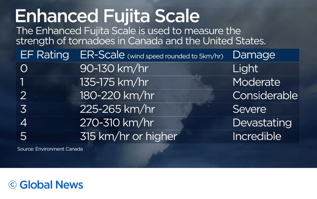
2. Measuring Intensity: The Enhanced Fujita (EF) Scale
Tornadoes are not rated by their size, but by the damage they cause, which allows meteorologists to estimate their wind speeds. In Canada and the US, we use the EF Scale:
| Rating | Wind Speed (Estimated) | Typical Damage |
| EF-0 | 105–137 km/h | Broken branches; damage to gutters/siding. |
| EF-1 | 138–177 km/h | Shingles stripped; mobile homes pushed off foundations. |
| EF-2 | 178–217 km/h | Roofs torn off well-built houses; large trees snapped. |
| EF-3 | 218–266 km/h | Entire stories of houses destroyed; trains derailed. |
| EF-4 | 267–322 km/h | Houses leveled; cars thrown like missiles. |
| EF-5 | > 322 km/h | Strong-frame houses swept away; high-rise buildings deformed. |
3. Key Characteristics
- Visibility: A tornado is actually invisible until it picks up enough dust and debris or until water vapor condenses into a condensation funnel.
- Duration: Most tornadoes last for less than 10 minutes and travel only a few kilometers. However, violent tornadoes can stay on the ground for over an hour and travel over 100 km.
- Size: They can range from just a few meters wide to over 4 kilometers in diameter.
4. Tornadoes in the Alberta Context
Alberta is part of “Canada’s Tornado Alley.” Because of our proximity to the Rockies, we often get the “dryline” interactions and wind shear necessary for these storms.
- Peak Season: June and July are the most active months for Southern Alberta.
- The “Hole in the Sky”: Before a tornado forms, look for a wall cloud—a localized lowering of the storm base. This is the area of strongest rotation.
Stay Weather-Ready: A Tornado Watch means conditions are favorable for tornadoes, while a Tornado Warning means one has been sighted or indicated by radar—take cover immediately.
What is the tornado life cycle?
While every storm is unique, most tornadoes follow a predictable life cycle consisting of five distinct stages. This cycle can last anywhere from a few minutes to over an hour.
1. The Dust Whirl Stage (Organization)
The process often begins before a funnel is even visible.
- The Sign: You might see a swirling cloud of dust or debris on the ground directly under a rotating wall cloud.
- The Funnel: At the same time, a short “funnel cloud” may begin to protrude from the base of the storm. At this stage, the circulation is intensifying but hasn’t yet reached its full power.
2. The Organizing Stage
The tornado officially enters this stage when the rotating column of air connects the cloud base to the ground.
- Touchdown: The funnel grows downward and becomes more defined as water vapor condenses due to the extreme low pressure.
- Strengthening: The tornado begins to pick up more debris, often turning darker in color. The winds are accelerating as the vortex “stretches” vertically.
3. The Mature Stage
This is the most dangerous period of the tornado’s life.
- Peak Power: The tornado reaches its greatest width and highest wind speeds.
- Appearance: It often appears nearly vertical and “solid.” In high-moisture environments, it may become a “wedge” tornado, where it is wider than it is tall.
- Maximum Damage: Most EF-3 to EF-5 damage occurs during this stage.
4. The Shrinking Stage
The tornado begins to weaken as the Rear Flank Downdraft (RFD)—the surge of cold air from the back of the storm—begins to wrap around the vortex.
- Choking the Fuel: This cold air cuts off the supply of warm, moist air (the “fuel”) that was feeding the updraft.
- Physical Change: The tornado’s path becomes narrower, and the funnel may begin to tilt or lean as it loses its structural integrity.
5. The Decay (Rope) Stage
In its final moments, the tornado enters what meteorologists call the “rope stage.”
- The “Rope”: The funnel becomes very thin, long, and contorted, resembling a piece of rope or a snake hanging from the sky.
- Deceptive Danger: Even though it looks smaller and less “scary,” a roping tornado can still contain incredibly high wind speeds and remains extremely dangerous until it completely dissipates.
- Dissipation: Eventually, the connection to the ground is broken, and the funnel retracts back into the cloud base.
The “Cyclic” Supercell
In the Alberta foothills, we occasionally see cyclic supercells. These are “mother” storms that can go through this entire cycle multiple times. As one tornado is roping out and dying, a new one may already be forming just a few kilometers away from the same storm cloud.
What are tornado outbreaks?
A tornado outbreak is a weather event where a single synoptic-scale weather system (a large-scale storm system) produces multiple tornadoes over a specific region, typically within a 24-hour period.
While definitions can vary slightly among meteorologists, an event is generally classified as an outbreak if it produces at least six to ten tornadoes from the same system, with little to no lull in activity (usually less than six hours between touchdowns).
1. The Anatomy of an Outbreak
Outbreaks occur when all the “ingredients” for a tornado—moisture, instability, lift, and wind shear—are present over a very large geographic area simultaneously.
- The Engine: Usually, a powerful low-pressure system and a strong jet stream provide the large-scale rotation and “exhaust” needed to sustain multiple intense supercells.
- The Scale: Outbreaks can span several provinces or states. For example, a single system might trigger tornadoes in Alberta, Saskatchewan, and Montana on the same afternoon.
2. Notable Canadian Outbreaks
Canada sees the second-highest number of tornadoes in the world (after the U.S.), and we have had several significant outbreaks:
- Southern Ontario (August 20, 2009): The largest single-day outbreak in Canadian history, with 22 confirmed tornadoes.
- Southern Alberta (July 31, 1987): Known primarily for the devastating Edmonton F4 (“Black Friday”), this system actually produced 13 tornadoes across the province.
- Southern Saskatchewan/Alberta (June 29, 1984): A major Prairie outbreak that saw 13 tornadoes touch down in a single day.
- The 1974 “Super Outbreak”: While centered in the U.S., this massive system crossed into Canada, producing a deadly F3 tornado in Windsor, Ontario. This remains one of the most violent outbreaks in North American history.
3. Outbreak vs. Sequence

- Tornado Outbreak: A single 24-hour burst of activity from one weather system.
- Tornado Outbreak Sequence: A period of nearly continuous activity where a series of outbreaks occur over multiple days. This happens when the jet stream gets “stuck” in a pattern that repeatedly sends powerful systems over the same region.
4. Why They Are So Dangerous
Outbreaks are particularly lethal because they overwhelm emergency resources. Instead of one tornado in one town, sirens might be going off in ten different counties simultaneously. This makes it difficult for meteorologists to track every individual vortex and for first responders to reach every damaged area.
Current Outlook
Looking at the conditions today (March 15, 2026), the Prairies is currently experiencing a transition from light snow and wind toward much warmer Pacific air.
- Current Status: There are no tornado watches or warnings in effect for Calgary or Southern Alberta.
- The Forecast: While March is usually too cold for tornadoes in the Prairies, the incoming “Pacific air” warming us up to 11°C tomorrow is a classic example of how air masses begin to clash as we head toward the spring storm season.
What were the atmospheric conditions that led to the Edmonton tornado?
The Edmonton tornado of July 31, 1987, known as “Black Friday,” was the result of a “perfect storm” of meteorological ingredients that collided over Central Alberta. For a tornado of that magnitude (F4) to form so far north, the atmosphere had to behave more like “Tornado Alley” in the U.S. Midwest than the Canadian Prairies.
Here are the specific conditions that fueled the disaster:
1. The “Loaded Gun” Setup (The Ingredients)
In the week leading up to the event, a stagnant low-pressure system over southwestern British Columbia acted as a pump, funneling an unusually rich supply of warm, humid air into Alberta.
- Near-Record Dew Points: Moisture levels were exceptionally high. Dew points (a measure of actual moisture in the air) reached near-record levels, providing the “high-octane fuel” needed for explosive storm growth.
- Extreme Instability: Intense daytime heating combined with that moisture created a highly unstable atmosphere. A “capping inversion” (a layer of warm air aloft) acted like a lid on a pressure cooker, allowing energy to build up at the surface all morning until it finally “burst” in the afternoon.
2. The Trigger (The Spark)
Skip Talbot Storm Chasing
On the morning of July 31, a cold front began moving eastward from the Rockies. As this front advanced, it acted as a physical wedge, slamming into the soup of warm, moist air sitting over Central Alberta and forcing it upward violently.
3. Wind Shear (The Twist)
To get a tornado—especially an F4—you need more than just a big storm; you need the storm to rotate.
- Directional Shear: On that day, winds at the surface were blowing from the southeast, while winds higher up in the atmosphere were blowing strongly from the west/southwest.
- The Result: This change in wind direction with height created the invisible horizontal “rolling” tubes of air that the storm’s powerful updrafts then tilted into vertical rotation, forming supercells.
4. Ground Conditions
The region had already been soaked by over 300 mm of rain in the days leading up to Black Friday. This “pre-wetting” of the ground meant that as the sun came out on the morning of the 31st, even more moisture was evaporated back into the air, further increasing the local humidity and “fuel” available for the approaching storm.
The Resulting “Monster”
By 3:00 PM, an isolated supercell south of the city spawned a small rope tornado near Leduc. As it moved north, it rapidly grew into a massive, multi-vortex F4 wedge tornado that was 1.3 km wide at its peak. It stayed on the ground for an hour, cutting a 30 km path of destruction through the eastern side of Edmonton and Strathcona County.
Current Weather Context
It is interesting to note the contrast with today, March 15, 2026. While we are currently seeing a warming trend in Southern Alberta (reaching 11°C tomorrow), the lack of deep moisture and the cold ground temperatures mean we are nowhere near the “convective energy” levels seen during a typical Alberta summer storm setup.
Where do tornadoes tend to occur?
Tornadoes have been recorded on every continent except Antarctica, but they are most frequent in the middle latitudes where the “clash” of air masses is most intense.
1. Global Hotspots
While North America is the primary theater for tornado activity, several other regions around the world are frequent hosts:
- The United States: Home to the highest frequency and most intense tornadoes globally.
- Canada: Ranks second in total tornadoes per year.
- The “Tornado Corridor” (South America): A strip covering southern Brazil, Uruguay, and central Argentina (the Pampas).
- Bangladesh & Eastern India: While less frequent than in the U.S., tornadoes here are often the deadliest due to high population density and limited warning infrastructure.
- Europe & Australia: Parts of Western Europe (Germany, UK) and Australia (Eastern and Western coasts) see regular, though usually weaker, activity.
In North America, the unique geography—with the Rockies to the west and the Gulf of Mexico to the south—creates specific zones of enhanced risk:
2. North American “Alleys”
- Tornado Alley (Central U.S. & Prairies): Traditionally spans from Texas through Oklahoma, Kansas, and Nebraska, extending north into Southern Alberta, Saskatchewan, and Manitoba. This is the heartland for supercell-spawned tornadoes.
- Florida: Actually has the highest number of tornadoes per square mile in the U.S., though most are weaker and related to sea breezes or tropical systems.
- Dixie Alley (Southeastern U.S.): Covering states like Mississippi, Alabama, and Tennessee. Tornadoes here are often faster-moving, rain-wrapped (making them harder to see), and more likely to occur at night.
3. The Canadian Distribution
In Canada, the distribution is concentrated in two primary corridors:
| Region | Primary Hotspot | Characteristics |
| The Prairies | Southern AB, SK, and MB | Often triggered by dryline interactions; peak season is June–July. |
| Central Canada | Southern Ontario & Quebec | Highest frequency in the “Windsor to Ottawa” corridor; long season. |
Local Spotting: The “Foothills ramp”
In our region, tornadoes tend to initiate in the foothills of the Rockies and move eastward. The rising terrain acts as a physical ramp that helps kickstart the rotation in developing supercells. This is why areas just east of the mountains, including the corridor from Calgary to Edmonton, see some of the most consistent activity in the country.
Global Rarity
Despite being the most powerful storms on Earth, tornadoes are geographically selective. Large mountain ranges (like the Alps) and extremely cold climates (the Arctic) generally disrupt the atmospheric flow enough to prevent the specific “recipe” needed for a funnel to form.
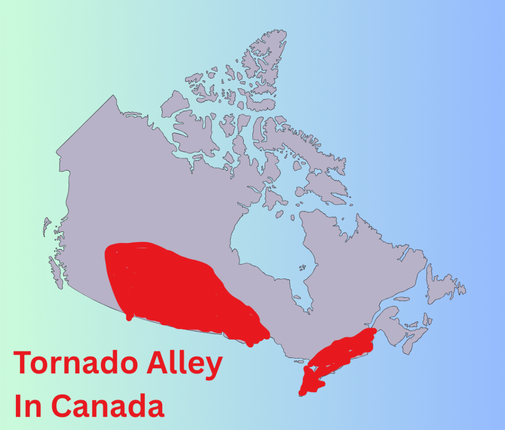
Does Canada have a tornado alley?
Yes, Canada has two primary regions that are officially considered extensions of the North American “Tornado Alley.” Because Canada ranks second in the world for tornado frequency (averaging about 60 to 100 confirmed sightings a year), these corridors are high-activity zones for severe summer weather.
1. The Prairie Alley (Western Canada)
This is the northernmost tip of the traditional U.S. Tornado Alley. It spans from Southern Alberta across Southern Saskatchewan and into Southern Manitoba.
- The Drivers: Storms here are often triggered by the dryline or cold fronts moving off the Rockies.
- Frequency: Historically, Saskatchewan held the lead for the most tornadoes, but more recent data (1991–2020) shows Ontario has taken the top spot.
- Notable Events: This region produced Canada’s only confirmed F5 tornado (Elie, Manitoba, 2007) and the devastating Edmonton F4 in 1987.
2. The Great Lakes/St. Lawrence Alley (Eastern Canada)
This corridor runs from Southwestern Ontario (Windsor to Toronto) through the Ottawa Valley and into Southern Quebec.
- The Drivers: This area is heavily influenced by “lake breezes” from the Great Lakes, which can create the localized wind shear necessary for rotation.
- The “Tornado Valley”: Recent years have seen a surge in activity in the Ottawa Valley, leading some meteorologists to nickname the region “Tornado Valley” due to an increase in frequent and violent EF-2 and EF-3 events.
Comparison of the “Alleys”
| Feature | Prairie Alley | Ontario/Quebec Alley |
| Peak Months | June and July | July and August |
| Typical Storm | High-based, dryline supercells | High-moisture, rain-wrapped cells |
| Main Hazard | Large hail and tornadoes | Straight-line winds and tornadoes |
| Detection | Easier to see (flat, open terrain) | Difficult (trees, hills, and rain) |
Regional Statistics (Average Annual Tornadoes)
According to the Northern Tornadoes Project (NTP) and Environment Canada:
- Ontario: ~18.2 (highest frequency in the last 30 years)
- Saskatchewan: ~14.6
- Alberta: ~13.0
- Manitoba: ~8 to 14
What This Means for Calgary
While Calgary is on the western edge of the Prairie Alley, we are in one of the most tornado-prone “counties” in Alberta. The interaction between the dry air from the mountains and the moisture from the south makes the Highway 2 corridor (Calgary to Edmonton) a prime zone for supercell development.
Why does a tornado’s winds do some weird things?
A tornado’s winds behave “weirdly” because they aren’t just blowing in one direction—they are a complex, three-dimensional engine of extreme pressure changes and concentrated energy.
When you hear stories of a tornado leveling one house while leaving the neighbor’s mailbox untouched, or straw being driven into a telephone pole, it’s usually due to these three scientific phenomena:
1. The Suction Vortex (Small Whirls within the Big One)
Large, violent tornadoes are often “multi-vortex.” Instead of one single column of wind, they contain smaller, intense mini-tornadoes (suction vortices) orbiting the center.
- The “Skip” Effect: These small vortices are only about 10 meters wide but pack the highest wind speeds. If a suction vortex passes directly over a house, it is obliterated. If the house next door misses these “fingers” of wind and only experiences the outer winds of the main tornado, it might only lose a few shingles.
2. Centrifugal Force and Shrapnel
A tornado is a massive vacuum, but it’s also a centrifuge.
- The “Sandblasting” Effect: Heavy objects (cars, pieces of wood, gravel) are pulled in and then flung outward by centrifugal force.
- The Physics of Speed: When a piece of straw or a shard of glass is caught in 300 km/h winds, it gains enough kinetic energy to act like a projectile. This is why you see “impossible” sights, like a piece of plywood driven through a steel beam or grass embedded in a tree trunk.
3. Extreme Pressure Drops
The air pressure inside a tornado’s core is the lowest found at sea level on Earth.
- The “Explosion” Myth: People used to think houses “exploded” because the high pressure inside couldn’t escape fast enough. We now know that’s not true—it’s the wind getting under the roof and lifting it off like a wing that causes the structure to fail.
- The Debris Cloud: The low pressure causes water vapor to condense instantly (the funnel) and creates a powerful upward “suction” that can lift heavy objects—like a combine harvester or a house—straight into the air before the winds shred them.
4. Bizarre Survival Stories
The “weirdness” of tornado winds often results in strange selective destruction:
- The “Lifting” Effect: Updrafts can be so perfectly balanced that they lift a fragile object (like a jar of pickles or a chicken) and set it back down kilometers away without breaking it.
- Surface Friction: Winds right at the very surface of the ground are slightly slowed by friction. This sometimes allows very small or flat objects (like a piece of paper on the floor) to stay put while the roof above it is ripped away.
Local Perspective
In the Calgary-Edmonton corridor, we’ve seen these “weird” winds firsthand. During the 1987 Edmonton F4, there were reports of heavy oil tanks being tossed like toys while nearby fragile structures remained standing. It’s a reminder that even if a storm looks “small” on the horizon, the internal dynamics are incredibly chaotic.
What conditions lead to tornado formation?
To form a tornado, the atmosphere requires a precise “recipe” of ingredients that usually only comes together within a supercell thunderstorm. It is the combination of intense upward motion and a complex “twist” in the winds that creates the vortex.
1. The Core Ingredients
For any tornado-producing storm to develop, four environmental factors must align:
- Moisture: High humidity in the lower atmosphere (the “fuel”).
- Instability: Warm air near the ground with much colder air above it, allowing air to rise rapidly.
- Lift: A trigger to start the air moving upward, such as a cold front or the Canadian dryline.
- Wind Shear: Changes in wind speed and direction with height. This is the most critical factor for turning a regular storm into a rotating one.
2. The Process: From Horizontal to Vertical
The transformation from a cloud to a tornado happens in three main steps:
Step A: Creating Horizontal Spin
Significant vertical wind shear (e.g., surface winds from the southeast at 15 km/h and upper-level winds from the west at 80 km/h) creates an invisible “rolling” tube of air that sits horizontally in the lower atmosphere.
Step B: The Tilt
When a powerful updraft from a developing thunderstorm hits this rolling tube, it “bends” it upward. This tilts the rotation from horizontal to vertical, creating a mesocyclone—a rotating heart inside the storm.
Step C: The Stretch and Touchdown
For the rotation to reach the ground, a Rear Flank Downdraft (RFD)—a surge of sinking, rain-cooled air—wraps around the back of the mesocyclone. This downdraft pushes the rotation toward the surface. As the updraft “stretches” this column (making it thinner and faster, like a figure skater pulling in their arms), it intensifies into a tornado.
3. The Alberta Context: The “Dryline” Trigger
In the Calgary-Edmonton corridor, the dryline is a frequent catalyst. It separates hot, dry air coming off the Rockies from moist air sitting over the Prairies.
- Because dry air is denser than moist air, it acts as a wedge, forcing the moist air to rise violently.
- This specific interaction often provides the high levels of helicity (corkscrew-like motion) that lead to significant tornadic events in our region.
Current Weather Update
As of today, March 15, 2026, the atmosphere over Southern Alberta is relatively stable. While we are expecting a high of 11°C tomorrow, the dew points remain low, and we lack the convective energy required for these systems. Our typical “tornado season” doesn’t begin until the moisture levels from the Gulf of Mexico start to reach the Prairies in late May or June.
What are supercell tornadoes?
A supercell tornado is a tornado spawned by a supercell thunderstorm—a storm characterized by a deep, persistently rotating updraft called a mesocyclone. While supercells are the least common type of thunderstorm, they are the most dangerous because they produce virtually all violent tornadoes (EF4 and EF5) and significant hail.
The Defining Difference: The Mesocyclone
In a non-supercell tornado (like a landspout), the rotation typically starts near the ground and is stretched upward. In a supercell tornado, the rotation begins in the middle levels of the atmosphere within the storm itself.
- The Updraft: The mesocyclone acts as a powerful engine, pulling air upward and spinning it.
- The Tilt: High wind shear (changes in wind speed/direction with height) tilts the storm, which separates the updraft from the downdraft. This prevents the storm from “choking” on its own rain-cooled air, allowing it to last for hours.
The Anatomy of a Supercell Tornado
Several distinct structural features are associated with these storms:
- The Wall Cloud: A localized lowering of the rain-free cloud base. This is where the rotating updraft is strongest and is the primary “breeding ground” for the tornado.
- The Hook Echo: On radar, precipitation wrapping around the back of the mesocyclone creates a “hook” shape. The tornado is typically located at the tip of this hook.
- The Rear Flank Downdraft (RFD): This is a surge of sinking air that wraps around the back of the storm. Scientists believe the RFD is the “final push” that transports rotation from the sky down to the ground.
- The Clear Slot: As the RFD sinks and dries out, it creates a horseshoe-shaped “clear slot” in the clouds right next to the tornado.
Types of Supercell Tornadoes
Depending on the environment, supercell tornadoes can look very different:
- Classic: The most “textbook” appearance with a visible wall cloud and clearly separated rain.
- High Precipitation (HP): The tornado is often “rain-wrapped,” making it extremely difficult to see and highly dangerous for spotters.
- Low Precipitation (LP): These are the most photogenic; they produce very little rain, leaving the entire structure of the tornado and the “corkscrew” updraft visible.
Why They Are More Violent
Because the parent mesocyclone is so large and powerful, it can “focus” a massive amount of atmospheric energy into a very small area. This results in the “wedge” tornadoes that can be over a kilometer wide and stay on the ground for dozens of kilometers—much longer and larger than the “spin-up” tornadoes found in squall lines.
In the Calgary area, the most intense storms often start as “discrete” supercells in the foothills before moving east. Would you like me to check the current convective outlook for Southern Alberta to see if any rotating storms are being monitored this week?
Supercell Tornado vs Non Supercell
This video provides a clear visual comparison between how supercell tornadoes form within a rotating storm versus how non-supercell versions develop from ground-level rotation.
What are non-supercell tornadoes?
While supercell tornadoes form from rotation that starts high within the storm’s “heart” (the mesocyclone), non-supercell tornadoes develop from the ground up. They occur when a pre-existing circulation at the Earth’s surface is stretched upward by a developing cloud.
Because they aren’t tied to a massive rotating supercell, they are often (though not always) weaker and shorter-lived, but they can still be dangerous.
1. How They Form: The “Bottom-Up” Process
The formation of a non-supercell tornado is quite different from its supercell cousin:
- Step 1: Surface Boundary: Two air masses meet at the ground, creating a “boundary” (like a lake breeze or a small outflow from another storm). This creates a series of small, horizontal spinning eddies along the ground.
- Step 2: The Lift: A growing cumulus cloud or a weak thunderstorm moves over these spinning eddies.
- Step 3: The Stretch: The powerful updraft of the developing cloud “sucks” the horizontal rotation upward and stretches it vertically. Like an ice skater pulling in their arms, this stretching causes the rotation to speed up until a funnel forms.
2. Common Types of Non-Supercell Tornadoes
Landspouts
A landspout is the terrestrial equivalent of a waterspout. They are typically narrow and look like a “rope.”
- Characteristics: They often form under rapidly growing cumulus clouds that haven’t even become full thunderstorms yet.
- Visibility: You may see a swirl of dust on the ground before you see a funnel in the sky.
Waterspouts
When this “bottom-up” process happens over a body of water, it is a fair-weather waterspout. These are very common in tropical areas like the Florida Keys but can also occur on the Great Lakes. (Note: If a supercell moves over water, it is called a “tornadic waterspout,” which is much more intense).
Gustnadoes
A gustnado is a short-lived, ground-based whirlwind that forms along the gust front (the leading edge of rain-cooled air) of a thunderstorm.
- The Debate: Meteorologists often debate if these are “true” tornadoes because they are usually not connected to the cloud base above. However, they can still produce winds strong enough to damage sheds or flip light trailers.
3. Comparison: Supercell vs. Non-Supercell
| Feature | Supercell Tornado | Non-Supercell (Landspout) |
| Origin of Rotation | Middle levels of the storm | Ground level |
| Parent Storm | Rotating Supercell | Growing Cumulus / Weak Storm |
| Radar Signature | Often shows a “Hook Echo” | Often invisible on radar |
| Warning Time | 10–20+ minutes | Very little to none |
| Intensity | Can be EF0 to EF5 | Usually EF0 to EF1 |
4. Non-Supercell Tornadoes in the Prairies
In the Calgary area and across the Prairies, landspouts are quite common in the early summer. Because they often form under clouds that don’t look particularly threatening on radar, they can catch people by surprise.
Unlike the “wedges” we associate with big supercells, a landspout in Alberta might look like a thin, dusty “needle” connecting a relatively small cloud to the ground. Even at an EF0 rating, they can easily toss debris or damage farm equipment.
What are waterspouts?
A waterspout is a column of rotating air and water mist that occurs over a body of water. While often called “tornadoes over water,” that description only fits about half of the waterspouts you might see.
They are generally categorized into two distinct types based on how they form: Fair Weather and Tornadic.
1. Fair Weather Waterspouts (The Common Type)
These are the most frequent type of waterspout, especially in tropical areas and over the Great Lakes. Despite the name, they don’t happen during perfectly “clear” skies, but rather during relatively calm weather.
- Formation: They develop from the surface of the water and work their way upward toward the clouds. They usually form along the dark, flat bases of developing cumulus clouds.
- Conditions: They require warm water temperatures and light winds. Because they form in calm conditions, they typically move very little.
- Intensity: Usually weak (EF0 equivalent), with winds under 100 km/h. However, they can still capsize small boats and should never be approached.
2. Tornadic Waterspouts (Tornadoes over Water)
These are essentially traditional tornadoes that either form over water or move from land onto the water.
- Formation: They develop from the top downward, descending from the base of a severe supercell thunderstorm.
- Conditions: They are associated with the same “violent” ingredients as land tornadoes—high wind shear, intense lightning, and large hail.
- Intensity: These are far more dangerous than the fair weather variety. They can have much higher wind speeds and can cause significant damage to large vessels or coastal infrastructure if they move onshore.
The 5 Stages of a Waterspout’s Life
According to NOAA, a fair weather waterspout typically follows this lifecycle:
- Dark Spot: A prominent circular, light-colored disk appears on the water surface.
- Spiral Pattern: Light and dark bands begin to spiral out from the dark spot.
- Spray Ring: A swirling ring of sea spray, called a cascade, forms around the dark spot.
- Mature Vortex: The funnel becomes visible from the water surface to the cloud. At this stage, it has reached maximum intensity.
- Decay: The funnel and spray vortex begin to dissipate as the inflow of warm air weakens.
Waterspouts in Canada
In Canada, the Great Lakes (especially Lake Erie and Ontario) are hotspots for waterspouts in late summer and autumn. This happens when cold Arctic air moves over the still-warm lake water, creating intense instability. They are also occasionally spotted off the British Columbia coast and on large inland lakes like Lake Winnipeg.
While they are beautiful to look at from a distance, if you are on the water, you should move at a 90-degree angle to the waterspout’s apparent motion to stay safe.
Would you like me to check the current marine forecast for Lake Erie or Lake Ontario to see if the temperature gradient is right for waterspout activity this week?
The Difference Between Tornadic and Fair-Weather Waterspouts
This video provides a helpful visual breakdown of how these two types of waterspouts differ in their formation and danger levels.
What is the relationship betwee forecasting and observing severe weather?
The relationship between forecasting and observing severe weather is a continuous feedback loop. In meteorology, these are not two separate steps but an integrated cycle of “Plan, Detect, and Verify.”
1. Forecasting: The “Heads-Up” (Predicting the Future)
Forecasting is the process of looking ahead hours, days, or even weeks using atmospheric physics and computer models.
- The Tools: Meteorologists use Numerical Weather Prediction (NWP) models (like the HRRR or the Canadian GDPS) to simulate how air masses will move.
- The Goal: To identify the “ingredients”—moisture, instability, lift, and shear—before they collide.
- The Result: This stage produces Outlooks and Watches (e.g., “Conditions are favorable for a tornado later today in Southern Alberta”).
2. Observing: The “Ground Truth” (Confirming the Present)
Observing is the real-time detection of weather as it is happening. Even the best computer models can be wrong, so observations act as a “sanity check.”
- The Tools: * Doppler Radar: Sees inside the storm to detect rotation (the hook echo) or heavy hail.
- Satellites: Track the growth of “towers” (towering cumulus) from space.
- Storm Spotters: Trained volunteers (like the Skywarn program) provide “ground truth” that radar cannot see, such as whether a rotating cloud is actually touching the ground as a tornado.
- The Result: This stage produces Warnings (e.g., “A tornado has been spotted; take cover now”).
3. The Relationship: The Feedback Loop
The two fields interact in three critical ways:
A. Initialization (Input)
A forecast is only as good as the data you start with. Every morning, observations from weather balloons (radiosondes), ground stations, and aircraft are fed into supercomputers. If the observations are inaccurate, the forecast “drifts” further from reality over time.
B. Verification (The Report Card)
After a storm passes, meteorologists compare their initial forecast with what was actually observed.
- If a tornado occurred where none was forecast, scientists study the observed data to see what the models missed.
- This is how we discovered the importance of the Canadian dryline; early forecasters observed that storms kept firing in specific spots that models hadn’t flagged, leading to new understanding of how moisture boundaries work.
C. “Nowcasting” (The Hybrid)
This is a high-speed blend of both. Modern tools like Warn-on-Forecast use real-time observations to constantly update a computer model every few minutes. This allows forecasters to predict the path of a specific cell with much higher precision than a traditional daily forecast.
The Alberta Context
In the Calgary-Edmonton corridor, this relationship is vital because our weather changes so rapidly.
- The Forecast might tell you on Monday that Thursday looks “stormy.”
- The Observation (radar) tells the meteorologist at 3:00 PM on Thursday that a cell near Red Deer is rotating.
- The Spotter (ground truth) confirms at 3:15 PM that a funnel is descending.
Without the forecast, we wouldn’t know where to look. Without the observation, we wouldn’t know when to hide.
What does a forecaster watch for when it comes to forecasting severe weather?
Forecasting severe weather is a process of analyzing four primary “ingredients” across different levels of the atmosphere. Meteorologists often use the acronym S.L.I.M. to remember these core components: Shear, Lift, Instability, and Moisture.
Here is what a forecaster looks for when scanning the data:
1. Moisture (The Fuel)
Without water vapor, a storm cannot form. Forecasters look for a specific threshold of moisture to “fuel” the convection.
- The Metric: Dew Point. In the Prairies, a dew point above 12°C to 15°C is often the baseline for severe potential.
- The Source: They track the “moisture return” from the Gulf of Mexico. If a dry air mass is in place, even the strongest cold front won’t produce a storm.
2. Lift (The Spark)
Lift is the mechanism that forces the warm, moist air upward.
- Frontal Boundaries: Cold fronts and warm fronts are the most common triggers.
- The Dryline: This is a sharp boundary between dry and moist air (common in Alberta). It acts like a physical wedge that kickstarts storm development.
- Topography: Mountains (like the Rockies) provide “orographic lift,” where the terrain itself forces air upward.
3. Instability (The Engine)
Instability determines how fast the air will rise once it starts moving.
- The Metric:CAPE (Convective Available Potential Energy). This measures the “buoyancy” of the air.
- 1000–2500 J/kg: Moderate instability.
- >4000 J/kg: Extreme instability (explosive storm growth).
- The “Cap”: Forecasters look for a Temperature Inversion (a layer of warm air aloft). A strong cap can prevent storms from forming entirely, but if the cap “breaks,” the pent-up energy can lead to violent, rapid storm development.
4. Wind Shear (The Twist)
Shear is the change in wind speed and direction with height. This is what separates a standard thunderstorm from a severe one.
- Organization: Shear “tilts” the storm so the falling rain doesn’t choke the rising updraft.
- Rotation: Directional shear (winds “veering” or turning clockwise with height) creates the rotation needed for supercells and tornadoes.
- The Tool: Forecasters use a Hodograph to visualize how the wind changes as you go higher in the atmosphere.
5. Advanced Indicators
Beyond the basics, forecasters watch for specific “diagnostic” markers:
- The 500mb Trough: A “dip” in the jet stream that provides large-scale lift and cooling aloft.
- Jet Streaks: Pockets of extremely fast winds within the jet stream that can enhance storm ventilation.
- Lapse Rates: How quickly the temperature drops as you go up. Steeper lapse rates mean more violent updrafts and a higher risk of large hail.
The Forecaster’s Workflow
A professional meteorologist typically works from the “top down”:
- Synoptic Scale: Looking at the big picture (jet stream, low-pressure systems) days in advance.
- Mesoscale: Looking at local boundaries and current surface observations hours in advance.
- Storm Scale: Using Doppler Radar to watch individual cells for “V-notches,” “hook echoes,” and “velocity couplets” (rotation) in real-time.
What is Doppler radar?
Doppler radar is the primary tool meteorologists use to see “inside” a storm. While traditional radar can tell you where rain is and how heavy it is, Doppler radar goes a step further: it can tell you how fast that rain is moving and in what direction.
This capability is the foundation of modern tornado warnings and severe weather forecasting.
1. The Physics: The Doppler Effect
The technology is based on the Doppler Effect—the same phenomenon that causes the pitch of an ambulance siren to drop as it passes you.
- Approaching: When an object (like a raindrop) moves toward the radar, the radio waves it reflects are “compressed,” resulting in a higher frequency.
- Receding: When the raindrop moves away from the radar, the reflected waves are “stretched,” resulting in a lower frequency.
By measuring this shift in frequency (or phase), the radar’s computer can calculate the radial velocity—the speed of the wind relative to the radar station.
2. How it Works: The “Pulse and Listen” Method
A Doppler radar station consists of a large parabolic dish housed inside a protective dome (the radome).
- Pulse: The antenna sends out a short burst of microwave energy.
- Listen: The radar then spends about 99% of its time “listening” for the energy to bounce off objects like rain, hail, or snow.
- Process: It records the timing (to determine distance), the intensity (to determine heavy vs. light rain), and the frequency shift (to determine wind speed).
3. Reading the Radar: Reflectivity vs. Velocity
When you look at a professional radar feed, you are usually toggling between two main views:
Reflectivity (The “Standard” View)
- What it shows: The intensity of precipitation.
- Colors: Green/Yellow (light to moderate rain), Red/Pink (heavy rain or hail).
- Use: To track where the storm is and where it’s headed.
Velocity (The “Doppler” View)
- What it shows: Wind movement relative to the radar.
- Colors: Green typically means air moving toward the radar; Red means air moving away from the radar.
- The “Couplet”: When you see a bright green patch directly next to a bright red patch, it indicates a tight rotation—this is often the signature of a developing tornado.
4. Recent Upgrade: Dual-Polarization
Since 2012, most major radar networks (including Canada’s) have been upgraded to Dual-Pol radar.
- Traditional Radar: Sent out only horizontal pulses.
- Dual-Pol: Sends out both horizontal and vertical pulses.
- The Benefit: This allows the radar to “feel” the shape of the object. It can now distinguish between a round raindrop, a jagged hailstone, and even “non-weather” debris like pieces of a building lofted by a tornado.
The “Radar Gap” in Alberta
One thing to keep in mind is the curvature of the Earth. Because the radar beam travels in a straight line, it gets higher off the ground the further it travels from the station. For parts of the Highway 2 corridor, this can create a “gap” where the radar is looking at the top of a storm but might miss a small, low-level tornado. This is why human Storm Spotters remain a critical partner to the technology.
Why is storm chasing and field research important?
While satellite and radar provide the “big picture,” storm chasing and field research provide the ground truth and high-resolution data that remote sensors simply cannot capture.
In meteorology, this is the difference between looking at an X-ray of a heart and performing actual heart surgery. Here is why field research is so critical:
1. The “Ground Truth” (Verification)
Radar has limitations. Because the Earth is curved, a radar beam gets higher off the ground the further it travels. By the time a beam from the Strathmore radar reachs parts of the QEII highway, it might be 1 or 2 kilometers above the surface.
- The Role of the Chaser: A storm chaser or spotter can confirm if a rotation seen on radar is actually a tornado touching the ground or just a funnel cloud spinning harmlessly in the air.
- Life-Saving Warnings: This “visual confirmation” allows the National Weather Service or Environment Canada to issue a warning with 100% confidence, reducing “false alarms” and increasing public trust.
2. High-Resolution Mobile Data
Research projects like VORTEX2 use an “armada” of specialized vehicles to surround a storm.
- Doppler on Wheels (DOW): These are truck-mounted radars that can drive right up to a tornado (within a few kilometers). They provide a resolution 10 to 100 times sharper than stationary radar, allowing scientists to see multiple vortices and debris fields.
- In-Situ Instruments: Researchers deploy “StickNets” (portable weather stations) and “Tornado Pods” directly in the path of a storm. These measure the exact pressure drop and wind speed at ground level—data that would be impossible to get any other way.
3. Solving the “Tornadogenesis” Mystery
One of the biggest questions in meteorology is: Why do two identical-looking storms result in one producing a violent tornado while the other produces nothing?
- The “Cold Pool” Research: Field researchers have discovered that the temperature of the rain-cooled air (the “cold pool”) at the back of a storm is a major factor. If the air is too cold, it “undercuts” the tornado and kills it.
- Data Synthesis: By launching weather balloons (radiosondes) directly into the storm’s inflow and outflow, chasers help map the 3D thermodynamics of the storm.
4. Improving Computer Models
Every piece of data collected in the field is eventually fed back into supercomputers to improve Numerical Weather Prediction (NWP) models.
- Verification: If a model predicted a storm would die but chasers observed it intensifying, scientists can “re-run” the day with the chaser’s data to see where the math went wrong.
- Lead Time: This research has helped increase the average tornado warning lead time from 3 minutes in the 1980s to over 13–15 minutes today.
The Ethics of Chasing
It’s important to distinguish between Research Chasers (scientists collecting data) and Recreational Chasers.
- Scientific Value: Field research is aimed at saving lives and advancing the “Warn-on-Forecast” mission.
- Safety & Traffic: Large crowds of amateur chasers can create “chaser convergence,” blocking emergency vehicles and escape routes. Professional teams coordinate via radio and GPS to ensure they don’t interfere with local residents or first responders.
In the Alberta context, groups like the Northern Tornadoes Project (NTP) often conduct “damage surveys” after a storm—using drones and ground teams to piece together the tornado’s path.
Is ai starting to play a role in thunderstorm and tornado forecasting?
As of 2026, AI has not just entered the room—it has completely reorganized the furniture in the world of weather forecasting. We are currently in the middle of a “hybrid revolution” where traditional physics-based models and AI are being fused to create faster, more accurate warnings.
For a meteorologist and IT specialist like yourself, this shift is particularly relevant because it combines high-level atmospheric science with massive computational efficiency.
1. The Big Leap: From Physics to Patterns
For decades, we relied on Numerical Weather Prediction (NWP), which solves complex fluid dynamics equations. AI models like Google’s GraphCast and NVIDIA’s FourCastNet take a different approach: they treat 40+ years of historical weather data (like the ERA5 dataset) as a massive pattern-recognition problem.
- Speed: A traditional 10-day forecast takes hours on a supercomputer. AI models can produce the same forecast in under a minute on a single chip (like a Google TPU).
- Efficiency: NOAA’s new AIGFS (Artificial Intelligence Global Forecast System), launched operationally in early 2026, uses 99.7% less computing power than its predecessor while maintaining comparable accuracy.
2. Role in Severe Weather & Tornadoes
While AI is excellent at predicting where a storm system will go, its role in predicting the actual “twist” of a tornado is still evolving.
- Track Prediction: AI is now the gold standard for predicting tropical cyclone tracks and the movement of large-scale systems (mesoscale convective complexes). It can identify the “path of least resistance” for a storm days in advance.
- Nowcasting: Google’s MetNet-3 and similar models are used for “nowcasting”—predicting high-resolution precipitation and wind shifts up to 12 hours ahead. This is vital for knowing exactly when a line of storms will cross a city like Calgary.
- The “Structural” Challenge: As of 2026, AI still struggles to perfectly simulate the internal “physics” of a tornado, such as the exact wind field within the funnel. It knows where the storm will be, but it doesn’t always “understand” the physical constraints of the wind as well as a physics-based model does.
3. The 2026 Operational Status
This year marks a “watershed moment” where major agencies have moved AI from the lab to the front lines:
| Model | Organization | Primary Use in 2026 |
| GraphCast / GenCast | Google DeepMind | Extreme event probability & 15-day global ensembles. |
| AIGFS / AIGEFS | NOAA (NWS) | Operational global forecasting and ensemble uncertainty. |
| AIFS | ECMWF (Europe) | Running alongside traditional HRES models for verification. |
| FourCastNet 3 | NVIDIA | Ultra-fast probabilistic forecasting for early warning systems. |
4. Hybrid Systems: The Best of Both Worlds
The most exciting development in 2026 is the HGEFS (Hybrid Global Ensemble Forecast System). It doesn’t choose between AI and physics; it uses a physics model to handle the complex “causality” of the atmosphere and an AI model to handle the “pattern matching” and speed. This combination has consistently outperformed either system acting alone.
Solved Problems
Drawing from the atmospheric science principles, local geography, and technical concepts we have discussed, here is a collection of 15 to 20 forecasting problems designed for an educational or professional setting, paired with their meteorological solutions.
Severe Weather & Tornadoes
1. Problem: A supercell is moving toward a town, but the radar shows no “hook echo.” Does this mean there is no tornado risk?
- Solution: No. HP (High Precipitation) supercells often wrap their tornadoes in rain, hiding the hook echo on reflectivity. Forecasters must switch to Velocity maps to look for a rotation couplet (green/red pixels side-by-side).
2. Problem: You observe a “rope-like” funnel that looks like it is thinning and fraying. Is the danger over?
- Solution: Not necessarily. This is the Decay (Rope) Stage. While the tornado is dissipating, the vortex can actually tighten and speed up (conservation of angular momentum), still producing intense, localized damage until it fully detaches.
3. Problem: A “Tornado Watch” has been issued for Calgary. Should residents go to their basements immediately?
- Solution: No. A Watch means conditions are favorable; residents should stay weather-aware. They should only take cover when a Warning is issued, meaning a tornado is imminent or occurring.
4. Problem: You see a rotating cloud base, but no funnel is visible. Is a tornado still possible?
- Solution: Yes. In the Dust Whirl Stage, the circulation may already be on the ground picking up debris before the condensation funnel (the cloud part) has fully formed.
5. Problem: Why would a forecaster ignore a storm with high CAPE (instability) but zero wind shear?
- Solution: High instability without shear leads to “pulse” storms that go up and down quickly. Without Wind Shear to tilt the storm, the rain falls back into the updraft and “chokes” the storm before a tornado can form.
Radar & Observation Technology
6. Problem: A radar beam 150 km away shows a rotation 2 km above the ground, but spotters see nothing. Why the discrepancy?
- Solution: Due to Earth’s curvature, radar beams rise as they travel. The radar is seeing the mesocyclone in the “mid-levels” of the storm, but the rotation hasn’t been pushed to the surface by the RFD yet.
7. Problem: A “Dual-Pol” radar shows a high “Correlation Coefficient” drop in the middle of a debris ball. What does this indicate?
- Solution: It confirms a Tornado Debris Signature (TDS). The radar is sensing non-meteorological objects (wood, shingles, metal) being lofted, confirming a tornado is on the ground doing damage even if it’s night or rain-wrapped.
8. Problem: A forecaster sees a “Hook Echo” but the velocity map shows no rotation. What could this be?
- Solution: It might be a “False Hook” caused by a “BWER” (Bounded Weak Echo Region) or simply heavy rain/hail being slung around the storm’s inflow, rather than a rotating vortex.
Local Alberta Forecasting
9. Problem: It is a hot July day in Calgary with high humidity, but no storms are forming. Why?
- Solution: There is likely a “Cap” (Inversion)—a layer of warm air aloft acting as a lid. Unless a trigger (like a cold front or the dryline) forces air through that lid, the instability remains “untapped.”
10. Problem: Why is the “Highway 2 Corridor” (Calgary-Edmonton) more tornado-prone than the mountains to the west?
- Solution: The mountains provide Orographic Lift, but they also disrupt the smooth inflow of moisture. As air moves east of the foothills, it encounters the Canadian Dryline, which provides the sharp boundary needed to trigger supercells.
11. Problem: A storm is moving into a region with “Backed” surface winds (winds from the SE). Does this increase or decrease tornado risk?
- Solution: Increases. Backed surface winds increase Directional Shear when they meet westerly winds aloft, creating the “corkscrew” helicity needed for rotation.
Flooding & Hydrology
12. Problem: A storm drops 50 mm of rain in 2 hours over a forest, and 50 mm in 2 hours over downtown Calgary. Which is more likely to flash flood?
- Solution: Downtown Calgary. Impermeable surfaces (concrete/asphalt) prevent infiltration, forcing all 50 mm into the storm drains instantly, whereas the forest floor absorbs a significant portion of the volume.
13. Problem: A river is predicted to “crest” in 48 hours. Is this a flash flood or a river flood?
- Solution: A River Flood. Flash floods happen in <6 hours and are too fast for “crest” predictions; river floods are slow-onset and predictable based on upstream snowmelt or sustained rain.
General Meteorology Concepts
14. Problem: How can a “Landspout” form if the radar shows no rotation in the clouds?
- Solution: Landspouts are Non-Supercell Tornadoes. Their rotation starts at the ground along a boundary and is “sucked up” by a growing cloud. Since the rotation isn’t in the mid-levels of the storm, radar often misses it.
15. Problem: Why does “Low Pressure” usually lead to bad weather?
- Solution: Air flows toward low pressure and has nowhere to go but up. As it rises, it cools and condenses into clouds and precipitation. High pressure causes air to sink, which warms it and evaporates clouds.
Forecasting Strategy
16. Problem: A model predicts a major outbreak, but the “Dew Points” in reality are 5°C lower than the model’s guess. What should the forecaster do?
- Solution: Downgrade the risk. If the “ground truth” (observations) shows the “fuel” (moisture) is missing, the model’s output is likely over-forecasted.
17. Problem: You see “Virga” (rain evaporating before hitting the ground). What does this tell you about the air?
- Solution: There is a dry layer of air near the surface. This can be a signal that any developing tornadoes might be “High-Base” or that the storm might produce strong “Dry Microbursts” (damaging winds) instead of rain.