
Meteorology Today Second Canadian Edition
Earth and Atmospheric Sciences
The relationship between air masses and fronts is essentially one of cause and effect. An air mass is a massive body of air with uniform temperature and moisture, while a front is the narrow boundary where two different air masses meet.
Weather Hunters – Weather Reporter | PBS KIDS
1. The Concept of Air Masses
An air mass forms when air sits over a specific region (a “source region”) long enough to take on its characteristics. For example, air over the Gulf of Mexico becomes warm and humid (maritime Tropical), while air over northern Canada becomes cold and dry (continental Polar).
As long as an air mass is moving alone, the weather remains relatively constant. The complexity begins when one air mass moves into a region occupied by another with different physical properties.
2. Fronts: The Transition Zone
Because different air masses have different densities (cold air is denser than warm air), they do not mix easily. Instead, they create a front. Think of a front as a “battleground” where the denser air mass pushes or slides under the lighter one.
How Different Fronts Form
- Cold Fronts: Occur when a cold, dense air mass advances and pushes under a warmer air mass. This often forces the warm air up abruptly, leading to narrow bands of intense rain or thunderstorms.
- Warm Fronts: Occur when a warm air mass slides up and over a retreating cold air mass. Because the slope is more gradual, this usually results in steady, widespread precipitation and layered clouds.
- Stationary Fronts: Form when two air masses meet but neither is strong enough to displace the other. They can hover over an area for days, often causing prolonged cloudy or rainy weather.
- Occluded Fronts: Happen when a fast-moving cold front catches up to a warm front, lifting the warm air mass entirely off the ground.
3. The Frontal Gradient
The “sharpness” of a front depends on the gradient—the degree of difference between the two air masses. If a very dry, cold air mass hits a very moist, warm air mass, the resulting front will be highly active with significant weather changes.
Summary Table
| Feature | Air Mass | Front |
| Size | Covers thousands of square miles. | Narrow, often only miles wide. |
| Properties | Uniform (homogenous). | High contrast (transition zone). |
| Weather | Generally stable and consistent. | Unsettled, windy, and precipitous. |
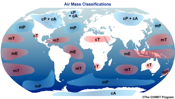
What are air masses?
An air mass is a massive body of air, often covering hundreds of thousands of square miles, that has relatively uniform characteristics of temperature and moisture (humidity) at any given altitude.
They are the “building blocks” of weather. When an air mass sits over a specific region for a long period, it adopts the characteristics of the surface below it. This region is known as a source region.
1. How Air Masses are Classified
Meteorologists classify air masses using a two-letter system based on their moisture content (lowercase letter) and their temperature (uppercase letter).
Moisture Content (Surface Type)
- m (maritime): Forms over oceans; the air is moist.
- c (continental): Forms over land; the air is dry.
Temperature (Latitude)
- A (Arctic/Antarctic): Extremely cold, forming near the poles.
- P (Polar): Cold, forming in high-latitude regions.
- T (Tropical): Warm or hot, forming near the equator and subtropics.
- E (Equatorial): Very hot and humid, forming directly over the equator.
2. Common Air Mass Combinations
By combining these letters, we can identify the specific “flavor” of the weather moving into a region:
| Type | Name | Characteristics |
| cP | continental Polar | Cold and dry (common in winter across North America). |
| mT | maritime Tropical | Warm and humid (often brings thunderstorms from the Gulf). |
| mP | maritime Polar | Cool and moist (brings “mucky” or foggy weather to coasts). |
| cT | continental Tropical | Hot and very dry (usually forms over deserts in summer). |
| cA | continental Arctic | Exceptionally cold and dry (the source of “Arctic blasts”). |
3. Modification and Movement
Air masses do not stay in one place forever. As they migrate, they undergo modification.
For example, if a cold cP air mass moves over the warmer Great Lakes, it picks up moisture and heat from below. This specific interaction is what causes lake-effect snow. The further an air mass travels from its source, the more it is influenced by the new terrain it crosses, eventually losing its original identity.
4. Why They Matter
The boundaries where these massive bodies of air clash are called fronts. Because air masses of different densities don’t mix easily, their interaction at these borders is the primary cause of wind, clouds, and precipitation.
What are source regions?
A source region is an extensive area of the Earth’s surface where an air mass remains stagnant long enough to acquire the temperature and moisture characteristics of the terrain below.
Think of it as a “molding chamber” for the atmosphere. If air sits over a tropical ocean for a week, it becomes warm and moisture-laden; if it sits over a frozen tundra, it becomes bitter cold and dry.
1. Requirements for a Source Region
Not every location on Earth can be a source region. For an area to effectively “label” a body of air, it must meet two primary criteria:
- Surface Uniformity: The area must be physically consistent. High-quality source regions are either entirely ocean or entirely flat land (like deserts or plains). Mountainous regions are poor source regions because their varying elevations and temperatures break up the air’s uniformity.
- Atmospheric Stagnation: The air must stay over the region for days or weeks. This usually occurs in areas dominated by high-pressure systems (anticyclones), where winds are light and air slowly sinks, spreading out to take on the surface’s properties.
2. Major Global Source Regions
Source regions are categorized by their latitude (which determines temperature) and their surface type (which determines moisture).
Tropical Source Regions (Low \ Latitudes)
- Gulf of Mexico / Caribbean: Provides warm, moist air (mT) to much of North America.
- Sahara Desert: A classic source for hot, extremely dry air (cT).
Polar and Arctic Source Regions (High \ Latitudes)
- Northern Canada / Siberia: Vast, flat, frozen landscapes that create cold, dry air (cP).
- North Pacific / North Atlantic: Chilly, damp regions that produce cool, moist air (mP).
3. Why the Mid-Latitudes are Not Source Regions
You might notice that the “middle” of the globe (like the central United States or Europe) is rarely listed as a source region. This is because these areas are transition zones.
In the mid-latitudes, the “clash” of air masses from the poles and the tropics creates constant wind and moving weather systems (the Jet Stream). Because the air is always moving, it never sits still long enough to take on a local “flavor.” Instead, these regions experience the weather brought in by air masses formed elsewhere.
4. Air Mass Modification
Once an air mass is pushed out of its source region by global wind patterns, it begins to change. A cold, dry air mass moving from the Canadian plains toward the Gulf of Mexico will gradually warm up and pick up moisture as it travels over different terrain.
How are air masses classified?
Air masses are classified using a two-letter system that describes their two most important characteristics: moisture content and temperature.
The first letter (lowercase) indicates the moisture, and the second letter (uppercase) indicates the temperature. By combining these, meteorologists can quickly identify the “personality” of the air moving into a region.
1. Moisture Content (Surface Type)
The lowercase letter tells you whether the air mass formed over land or water. This determines how much water vapor the air holds.
- m (maritime): Forms over oceans. This air is humid and moist because it has evaporated water from the sea.
- c (continental): Forms over land. This air is dry because large landmasses have limited moisture to offer the atmosphere.
2. Temperature (Latitude)
The uppercase letter tells you the latitude where the air mass originated, which determines its heat energy.
- A (Arctic): Extremely cold air from the highest latitudes (near the poles).
- P (Polar): Cold to cool air from high-latitude regions (like Canada or the North Pacific).
- T (Tropical): Warm to hot air from low-latitude regions (near the equator and subtropics).
- E (Equatorial): Very hot and exceptionally humid air forming directly over the equator.
3. Common Classifications
When we put these letters together, we get the five primary air masses that influence global weather:
| Code | Name | Description | Typical Weather |
| cA | continental Arctic | Extremely cold and dry | Bitter “Arctic blasts” and clear skies. |
| cP | continental Polar | Cold and dry | Refreshing in summer; cold and stable in winter. |
| mP | maritime Polar | Cool and moist | Damp, cloudy, and “mucky” weather. |
| mT | maritime Tropical | Warm and humid | Sticky “sauna” days and afternoon thunderstorms. |
| cT | continental Tropical | Hot and dry | Blistering heat waves with very low humidity. |
4. Stability and Modification
Sometimes, a third letter is added to describe the stability of the air mass relative to the surface it is traveling over:
- k (kalt): The air mass is colder than the surface below it. This causes the air to rise (convection), often leading to clouds and showers.
- w (warm): The air mass is warmer than the surface below. This makes the air stable, often resulting in fog or low-hanging stratus clouds.
For example, a mPk air mass is a cool, moist body of air that is colder than the ground it’s moving over, which typically produces puffy cumulus clouds.
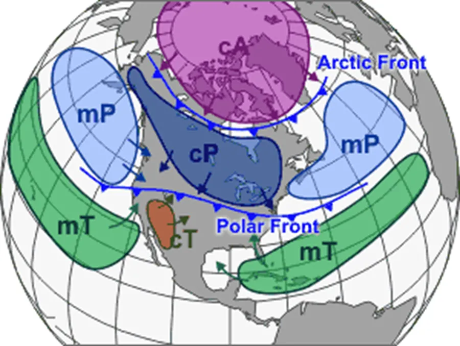
What are the air masses of North America?
Elisabeth Snipes Spring
North America is a unique meteorological crossroads. Because the continent is wide and lacks east-west mountain ranges in its center, air masses from the Arctic, the tropics, and two different oceans can move freely and collide.
The weather across the continent is primarily driven by five major air masses.
1. continental Polar (cP) and continental Arctic (cA)
These are the “refrigerators” of North America. They originate over the vast, flat, frozen reaches of Northern Canada and Alaska.
- Characteristics: Very cold and very dry.
- Impact: In winter, cA air brings “Arctic blasts” that can push temperatures far below zero. In summer, cP air provides a welcome relief from heat and humidity, bringing clear, cool, and crisp days.
- Modification: When these air masses move over the Great Lakes in winter, they pick up moisture and heat, resulting in heavy lake-effect snow on the leeward shores.
2. maritime Tropical (mT)
This is the “sauna” air mass. It primarily originates from the Gulf of Mexico, the Caribbean Sea, and the subtropical western Atlantic.
- Characteristics: Warm, very unstable, and loaded with moisture.
- Impact: It is responsible for the hot, oppressive humidity felt across the Eastern and Central U.S. and Canada during the summer. It provides the fuel for most afternoon thunderstorms and is a key ingredient for hurricane development.
- Inland reach: Because there are no mountains blocking the way, mT air can travel as far north as the Canadian Prairies.
3. maritime Polar (mP)
These air masses originate over the North Pacific and North Atlantic oceans. They are “milder” than their continental cousins but much more humid.
- Pacific mP: Typically brings cool, damp weather to the West Coast. As it hits the Rocky Mountains, it is forced upward, losing its moisture as rain or snow (orographic lifting) and reaching the interior as much drier air.
- Atlantic mP: Often moves into the Northeast (New England and the Maritimes) during the winter, contributing to the powerful “Nor’easters” that bring heavy snow and wind.
4. continental Tropical (cT)
This is the smallest and most seasonal air mass in North America, forming only during the summer over the desert Southwest (Arizona, New Mexico) and Northern Mexico.
- Characteristics: Hot and extremely dry.
- Impact: It brings blistering heat waves to the Southwest and Great Plains. It is very stable at the surface but can contribute to “dry lightning” and high fire risks.
Summary of North American Air Masses
| Air Mass | Source Region | Primary Impact |
| cA / cP | Northern Canada / Arctic | Cold waves, lake-effect snow, dry summer air. |
| mT | Gulf of Mexico / Atlantic | High humidity, thunderstorms, hurricanes. |
| mP | North Pacific / North Atlantic | Fog, drizzly rain, coastal snowstorms. |
| cT | Southwest U.S. / Mexico | Heat waves, drought conditions. |
What are lake-effect snows?
Lake-effect snow is a localized atmospheric phenomenon that occurs when a cold, dry air mass moves across a relatively warm, large body of water. This interaction transforms a clear winter day into a localized blizzard with intense snowfall rates, sometimes exceeding 5 inches per hour.
While most famous in the Great Lakes region of North America, it also occurs near the Great Salt Lake, the Finger Lakes, and even the Sea of Japan.
1. How It Forms: The “Recipe” for Snow
For lake-effect snow to develop, several specific meteorological conditions must align:
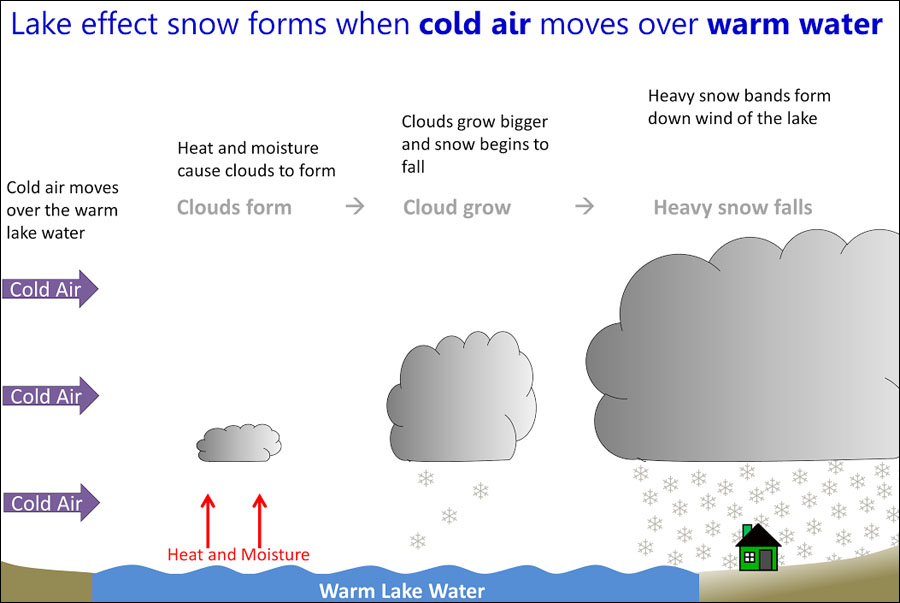
- The Temperature Gap: A cold air mass (usually continental Polar or Arctic) must move over much warmer lake water. Specifically, the temperature difference between the lake surface and the air about 5,000 feet up must be at least 13°C (23°F).
- Moisture & Heat Pickup: As the cold air travels over the water, it acts like a sponge. It warms slightly and picks up large amounts of water vapor from the lake.
- Convection: The warmed air becomes less dense and rises rapidly. As it rises, the moisture cools and condenses into clouds (specifically convective cumulus clouds).
- The “Fetch”: This is the distance the air travels over open water. A longer fetch (more water to cross) allows the air to pick up more moisture, leading to heavier snow bands.
2. The Landing: Orographic & Frictional Lifting
Once the clouds reach the downwind (leeward) shore, two things happen to force the snow out:
- Frictional Convergence: Air moves faster over smooth water than it does over rough land. When the wind hits the shoreline, it slows down and “piles up,” forcing the air upward and intensifying the snowfall.
- Topography: If the land rises into hills or mountains (like the Tug Hill Plateau in New York), the air is forced even higher, cooling it further and squeezing out every last drop of moisture as snow.
3. Key Characteristics
- Extreme Locality: It can be sunny and clear just 10 miles away from a massive snow band. The snow falls in narrow, intense “squalls.”
- The “Crystal” Factor: Lake-effect snow is often very light and “fluffy” because it forms at lower altitudes and colder temperatures than typical storm snow.
- Seasonality: It is most common in late autumn and early winter (November–January). Once a lake freezes over, the “moisture engine” shuts off, and the lake-effect snow stops.
4. Why it Matters
Lake-effect snow can be incredibly disruptive because of its unpredictability and intensity. It often creates “whiteout” conditions on highways within seconds of driving into a band. Cities like Buffalo, New York, and Grand Rapids, Michigan, are among the snowiest in the world precisely because of their location downwind of the Great Lakes.
What are arctic outbreaks?
An Arctic outbreak (often called an “Arctic blast” or “Polar surge”) is a weather phenomenon where an exceptionally cold, dry air mass—typically continental Arctic (cA)—plunges southward from the polar regions into mid-latitude areas.
In North America, these events are responsible for the most extreme temperature drops of the winter season, often causing temperatures to fall 20°C to 30°C within a single day.
1. The “Gatekeeper”: The Polar Vortex and Jet Stream
Under normal conditions, the Polar Vortex (a large area of low pressure and cold air surrounding the Earth’s poles) is held in place by the Jet Stream, a high-altitude ribbon of fast-moving air.
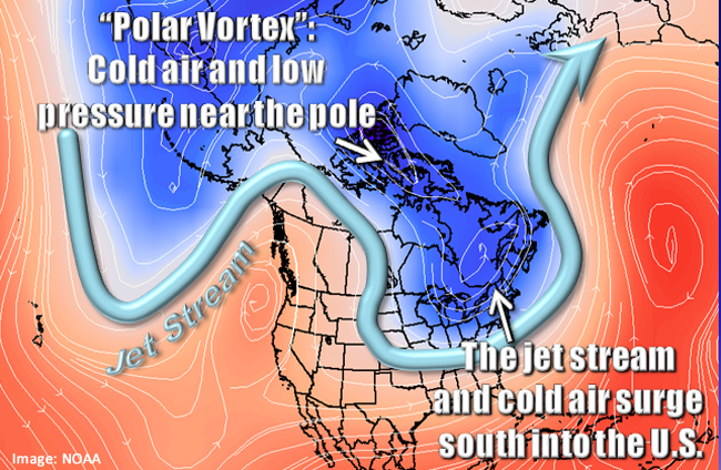
- The Stable State: When the Jet Stream is strong and straight, it keeps the frigid Arctic air “locked” up north.
- The Outbreak State: If the Jet Stream weakens or becomes “wavy” (due to atmospheric blocking or sudden stratospheric warming), it develops large loops. A deep southward dip—called a trough—acts like an open gate, allowing the heavy, dense Arctic air to pour down into southern regions.
2. Characteristics of the Air Mass
Arctic outbreaks are driven by the continental Arctic (cA) air mass, which forms over the snow-covered surfaces of the Arctic Circle, Northern Canada, or Siberia.
- Extreme Density: This air is very cold and therefore very dense (heavy). Because it is so heavy, it stays close to the ground, sliding under warmer air like a wedge.
- Low Moisture: Since cold air cannot hold much water vapor, the humidity is extremely low. This leads to the “biting” dry cold that characterizes these events.
- High Pressure: These outbreaks are almost always associated with a massive High-Pressure System (Anticyclone) that originates in the north.
3. Impact and Associated Weather
While the primary feature is the extreme cold, Arctic outbreaks trigger several other weather events:
- The “Blue Northie”: In the Great Plains, a rapid temperature drop often occurs under clear, deep blue skies as the dry Arctic air displaces the moist, cloudy air.
- Lake-Effect Snow: As the frigid air crosses the relatively warmer Great Lakes, it triggers intense, localized snow squalls.
- Dangerously High Wind Chills: Because the air mass is moving rapidly, the combination of wind and cold creates life-threatening wind chill factors, increasing the risk of frostbite and hypothermia.
- Freeze Lines: These outbreaks can push “freeze lines” deep into the south, potentially damaging citrus crops in Florida or causing infrastructure issues in regions not built for sub-zero temperatures.
4. The Modification Process
As the Arctic air mass travels south, it undergoes modification. It picks up heat and moisture from the ground and water it passes over. By the time an Arctic blast from Northern Canada reaches the Gulf Coast, it is significantly warmer than when it started, though it still feels exceptionally cold relative to the local climate.
What are fronts?
Pilot Institute Airplanes
A front is a transition zone or boundary between two different air masses. Because air masses have different densities—primarily due to differences in temperature and moisture—they do not mix easily. Instead, they clash, much like oil and water, creating a weather “battleground.”
Fronts are responsible for almost all significant weather changes, including wind shifts, temperature swings, and precipitation.
1. How Fronts Form
A front is created when one air mass moves into a region occupied by another. The denser air mass (the colder one) always acts as a wedge, forcing the lighter, warmer air mass to rise. As this warm air rises, it cools and condenses, forming clouds and eventually rain or snow.
2. The Four Primary Types of Fronts
Each type of front is defined by which air mass is “winning” the battle and how it moves.
Cold Fronts
A cold front occurs when a cold, dense air mass advances and pushes under a warmer air mass.
- Movement: Faster than warm fronts.
- Weather: Because the cold air is so dense, it lifts the warm air abruptly. This often leads to a narrow band of intense weather, such as heavy rain, thunderstorms, or even tornadoes.
- Map Symbol: A blue line with triangles pointing in the direction of movement.
Warm Fronts
A warm front occurs when a warm air mass slides up and over a retreating cold air mass.
- Movement: Slower and more gradual than cold fronts.
- Weather: The warm air rises at a gentle angle, creating widespread, layered clouds (stratus) and steady, light-to-moderate precipitation that can last for a day or more.
- Map Symbol: A red line with semi-circles pointing in the direction of movement.
Stationary Fronts
A stationary front forms when two air masses meet, but neither is strong enough to displace the other. They essentially “stall” against each other.
- Weather: These can cause prolonged periods of cloudy, wet weather as the boundary hovers over the same area for days.
- Map Symbol: An alternating line of blue triangles and red semi-circles pointing in opposite directions.
Occluded Fronts
An occluded front happens when a fast-moving cold front catches up to a slower-moving warm front. The warm air is squeezed upward and completely “cut off” (occluded) from the ground.
- Weather: This usually indicates a maturing storm system and can bring a complex mix of clouds and precipitation.
- Map Symbol: A purple line with both triangles and semi-circles pointing in the direction of movement.
3. How to Identify a Frontal Passage
When a front passes over your location, you will notice several distinct changes in the “state of the atmosphere”:
- Temperature: A sharp rise or fall.
- Wind: A noticeable shift in wind direction (e.g., from South to Northwest).
- Pressure: The barometric pressure usually drops as the front approaches and rises after it passes.
- Dew Point: A change in how “sticky” or dry the air feels.
What are stationary fronts?
A stationary front is a weather boundary between two air masses that has stalled. It occurs when neither the cold air mass nor the warm air mass is strong enough to displace the other, resulting in a “standoff” where the frontal boundary moves very little—typically less than 5 miles per hour.
On a weather map, a stationary front is represented by a line with alternating blue triangles pointing toward the warmer air and red semi-circles pointing toward the colder air.
1. How Stationary Fronts Form
Stationary fronts usually form when the winds on either side of the boundary are blowing parallel to the front rather than toward or away from it. Without a wind component to push the air mass forward, the boundary stays fixed in place.
2. Typical Weather Patterns
Because the front doesn’t move, the weather associated with it can persist for several days, sometimes leading to localized flooding.
- Cloud Cover: As warm, moist air is forced to rise slowly over the colder air mass (a process called overrunning), it cools and condenses into extensive layers of clouds.
- Precipitation: These fronts are known for long periods of steady, light-to-moderate rain, drizzle, or snow. Unlike the quick “clearing” you see after a cold front, a stationary front keeps the sky grey and damp for a long time.
- Temperature Contrast: If you cross a stationary front, you will experience a noticeable temperature change, but it won’t be as sudden or violent as the shift found in an active cold front.
3. How a Stationary Front Ends
A stationary front remains until there is a change in the upper-level atmospheric pressure or wind patterns. It usually resolves in one of three ways:
- Becomes a Cold Front: The cold air mass gains momentum and begins to push south.
- Becomes a Warm Front: The warm air mass gains momentum and begins to slide north.
- Dissipates: The temperature and moisture differences between the two air masses fade away (a process called frontolysis), and the boundary simply disappears.
4. Risks: Training and Flooding
One of the primary hazards of a stationary front is “training.” This happens when multiple rain cells or thunderstorms move along the length of the stationary boundary, like cars on a train track. Because the boundary isn’t moving, the same town can get hit by storm after storm, leading to significant rainfall totals and flash flooding.
What are cold fronts?
A cold front occurs when a cold, dense air mass advances and replaces a warmer, lighter air mass. Because cold air is denser, it acts like a “snowplow,” sliding under the warm air and forcing it to rise abruptly into the atmosphere.
Cold fronts are known for bringing the most dramatic weather changes, including sudden temperature drops, intense storms, and rapid shifts in wind direction.
1. Structure and Movement
Cold fronts are typically characterized by a steep slope. As the cold air pushes forward, the friction with the ground causes the leading edge to bulge and steepen.
- Speed: They move faster than any other type of front, typically averaging 30 to 50 km/h (20 to 30 mph), though they can move much faster during intense winter outbreaks.
- The “Lifting” Mechanism: Because the front is so steep and fast-moving, it forces the warm, moist air in its path to rise vertically and very quickly.
2. Weather Before, During, and After
The passage of a cold front is usually very easy to identify because the weather changes follow a predictable sequence.
Before the Front
- Temperature: Warm.
- Pressure: Steadily falling.
- Clouds: Increasing and thickening (usually cirrus followed by altocumulus).
- Winds: South to Southwest.
During the Front (The “Frontal Passage”)
- Temperature: Sudden, sharp drop.
- Pressure: Reaches its lowest point, then begins a sharp rise.
- Weather: High-intensity precipitation. If the warm air being lifted is unstable, it creates cumulonimbus clouds, leading to heavy rain, thunderstorms, lightning, and occasionally hail or tornadoes.
- Winds: Gusty and shifting (often from South to West or Northwest).
After the Front
- Temperature: Cold and falling.
- Pressure: Steadily rising.
- Clouds: Clearing rapidly. You may see scattered cumulus clouds, but the sky often turns a deep, crisp blue.
- Winds: West to Northwest.
3. Map Representation
On a weather map, a cold front is represented by a solid blue line with triangles. The triangles act like arrows, pointing in the direction that the cold air is moving.
4. Squall Lines
Sometimes, a particularly strong cold front will develop a squall line. This is a narrow, long band of high-wind thunderstorms that forms right along or just ahead of the front. Squall lines are often responsible for “straight-line wind damage” and can be hundreds of miles long.
What are warm fronts?
A warm front occurs when a warm air mass advances and slides upward over a retreating colder, denser air mass. Because the warm air is less dense, it cannot easily displace the cold air at the surface. Instead, it “overruns” the cold air, creating a very gradual, gentle slope.
Warm fronts are associated with long-lasting, widespread weather changes rather than the sudden, violent bursts typical of cold fronts.
1. Structure and Movement
The slope of a warm front is much shallower than that of a cold front—often a ratio of about 1:200. This means for every 1 mile of vertical rise, the front extends 200 miles horizontally.
- Speed: They move slowly, typically half as fast as cold fronts (about 15 to 25 km/h).
- The “Overrunning” Process: As the warm air climbs the “ramp” of cold air, it cools adiabatically. This leads to the formation of a predictable sequence of clouds that can extend hundreds of miles ahead of the actual surface front.
2. The Cloud Sequence
One of the most reliable ways to predict an approaching warm front is by watching the sky. Because the front is slanted, the highest clouds appear first, long before the rain starts.
- Cirrus: Thin, wispy “mare’s tails” are the first sign, appearing up to 1,000 km ahead of the front.
- Cirrostratus: A thin veil that often creates a “halo” around the sun or moon.
- Altostratus: The sky turns a uniform grey, and the sun becomes a “watery” dim disk.
- Nimbostratus: Thick, dark clouds that bring steady, continuous precipitation.
3. Weather Before, During, and After
While a cold front is like a “shock,” a warm front is a “soak.”
Before the Front
- Temperature: Cool to cold.
- Pressure: Slowly falling.
- Winds: East to Southeast.
- Precipitation: Light to moderate rain, snow, or sleet that lasts for hours or even days.
During the Front (The “Frontal Passage”)
- Temperature: Rising steadily.
- Pressure: Levels off.
- Winds: Shifting to the South or Southwest.
- Weather: Precipitation tapers off into a drizzle or stops entirely, though fog often forms as the warm, moist air meets the cool, damp ground.
After the Front
- Temperature: Warmer and more humid.
- Pressure: Slight rise followed by a fall.
- Clouds: Clearing or scattered cumulus; the sky becomes “hazy” due to increased moisture.
- Winds: South to Southwest.
4. Map Representation
On a weather map, a warm front is represented by a solid red line with semi-circles. The semi-circles point in the direction that the warm air is moving.
5. Potential Hazards: Freezing Rain
In the winter, warm fronts are the primary cause of freezing rain and ice storms. As the warm air overruns the cold air, rain falls through a shallow layer of sub-freezing air near the ground. The raindrops become “supercooled” and freeze instantly upon hitting the cold surface (like roads or power lines).
What is the wavy warm front?
a “wavy” front refers to the development of a frontal wave (or wave cyclone). This occurs when a stable, straight stationary front begins to ripple, creating a bend or “wave” that eventually develops into a full-scale low-pressure storm system.
This process is the birth of a mid-latitude cyclone, the primary weather maker for much of North America.
1. How the “Wave” Forms
A stationary front separates cold polar air from warm tropical air. If an upper-level disturbance (like a ripple in the Jet Stream) passes over this boundary, it causes the air pressure to drop at a specific point along the front.
- The Bend: As the pressure drops, winds begin to circulate counter-clockwise (in the Northern Hemisphere) around the low.
- The Division: This circulation pushes the cold air southward on the west side of the low and pulls the warm air northward on the east side.
- The Result: The once-straight stationary front now looks like a wave on a map, with a warm front forming the leading edge of the wave and a cold front forming the trailing edge.
2. Weather Along the Wavy Front
The “wavy” appearance indicates that a storm is intensifying. You will see two distinct weather zones:
- The Warm Sector: The area between the cold and warm fronts. Here, the weather is relatively clear, warm, and humid.
- The Overrunning Zone: Ahead of the “warm” part of the wave, warm air is sliding up over the cold air, creating a massive shield of clouds and steady precipitation.
3. The Lifecycle of the Wave
Meteorologists use the Norwegian Cyclone Model to describe how this wave evolves:
- Nascent Stage: The first “kink” or wave appears on the stationary front.
- Mature Stage: The wave becomes very distinct. The central low-pressure deepens, and the cold front begins to “chase” the warm front.
- Occlusion: Because cold fronts move faster than warm fronts, the cold front eventually catches up, zipping the two fronts together to form an occluded front. This is the peak of the storm’s intensity.
4. Why “Wavy” Matters for Forecasting
If a weather map shows a stationary front turning “wavy,” it is a warning sign that a storm is organizing.
- For Calgary: When a wave develops along a front pinned against the Rockies, it can lead to “upslope” conditions, where moisture is forced against the mountains, resulting in heavy, prolonged snowfall or rain.
What are drylines?
A dryline is a unique meteorological boundary that separates a moist air mass from a completely dry air mass. Unlike cold or warm fronts, which are defined by temperature differences, a dryline is defined by a sharp contrast in dew point and humidity.
In North America, drylines are most common in the Great Plains, particularly across Texas, Oklahoma, and Kansas during the spring and summer.
1. The Anatomy of a Dryline
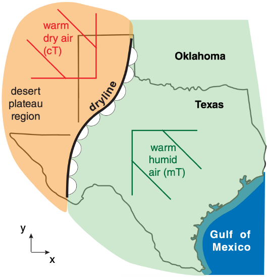
A dryline typically forms when two specific air masses meet:
- maritime Tropical (mT): Warm, humid air flowing north from the Gulf of Mexico.
- continental Tropical (cT): Hot, very dry air flowing east from the desert Southwest and Mexican plateau.
Because dry air is actually denser than moist air (at the same temperature), the dry air mass acts as a wedge, forcing the moist air to rise. This lifting mechanism is why drylines are often the “spark” for explosive storm development.
2. Dryline Characteristics
The transition across a dryline can be incredibly sharp, often occurring over just a few miles.
- The Dew Point Drop: You might see a dew point of 21°C (70°F) on the east side of the line and a bone-dry -1°C (30°F) on the west side.
- Visibility: The dry side often has exceptional visibility and clear skies, while the moist side may be hazy or cloudy.
- Wind Shift: Winds usually shift from the south or southeast on the moist side to the west or southwest on the dry side.
3. Severe Weather “The Dryline Bulge”
Drylines are famous for producing supercell thunderstorms. During the afternoon, as the sun heats the ground, the dryline often moves eastward. If the line “bulges” or moves rapidly, it provides intense lift.
If the atmosphere is unstable, this lift can trigger a line of storms that often produce:
- Large hail.
- High winds.
- Strong tornadoes.
4. Diurnal Movement
Drylines have a distinct daily “rhythm”:
- Daytime: The dryline typically moves eastward as the sun heats the surface and dry air from higher altitudes mixes down to the ground.
- Nighttime: As the sun sets and the surface cools, the humid Gulf air often surges back westward, sometimes retreating over a hundred miles by morning.
Summary Table: Dryline vs. Cold Front
| Feature | Dryline | Cold Front |
| Primary Contrast | Moisture (Dew Point) | Temperature |
| Air Masses | cT vs. mT | cP/cA vs. mT |
| Movement | Moves East (day), West (night) | Generally moves South/East |
| Typical Clouds | Isolated Cumulus to Supercells | Linear Squall Lines |
What are occluded fronts?
An occluded front occurs during the mature stage of a mid-latitude cyclone’s life cycle. Because cold fronts generally move faster than warm fronts, the cold front eventually catches up to the warm front, “zipping” them together.
When this happens, the warm air mass is forced completely off the ground, trapped between two cooler air masses. This process is called occlusion, which literally means “cut off” or “closed.”
1. How Occlusion Happens
Imagine a three-part system: a cold air mass, a warm air mass, and a cool air mass.
- The fast-moving cold front (trailing) overtakes the slower warm front (leading).
- The warm air between them is squeezed upward.
- The two cooler air masses meet at the surface, leaving the warm air “suspended” aloft.
2. Types of Occluded Fronts
There are two variations depending on which of the two non-warm air masses is colder.
Cold-Type Occlusion
This is the most common type in North America (especially in the interior). The air behind the cold front is colder than the air ahead of the warm front. The advancing cold air acts as a wedge and slides under both the warm air and the cool air.
Warm-Type Occlusion
This is common along the West Coast (like the Pacific Northwest or British Columbia). The air behind the cold front is actually milder than the stagnant, freezing air sitting over the land. The advancing air slides up and over the heavier, colder air.
3. Weather Patterns
Occluded fronts usually bring the most complex and unsettled weather of a storm’s lifecycle, as they combine elements of both cold and warm fronts.
- Before the Front: Similar to a warm front, you’ll see thickening clouds and steady precipitation (rain or snow).
- During the Front: The weather can be quite violent. You may experience heavy rain and thunderstorms (from the lifting of the warm air) followed immediately by the cold-front characteristics of gusty winds and dropping temperatures.
- After the Front: The sky usually begins to clear, and the air becomes significantly drier and cooler.
4. Map Representation
On a weather map, an occluded front is represented by a solid purple line with both triangles and semi-circles pointing in the direction of movement.
Note: The purple color is a literal mix of the blue (cold front) and red (warm front) symbols.
5. Significance in Forecasting
An occluded front usually signals that a storm system has reached its maximum intensity. Once the front is fully occluded, the “fuel” for the storm (the warm, moist air) has been lifted away from the surface. Shortly after this stage, the low-pressure system typically begins to weaken and dissipate.
What air upper air fronts?
While surface fronts are the most commonly discussed boundaries in meteorology, upper-air fronts (often called “fronts aloft”) occur high in the troposphere, typically between 3,000 and 10,000 meters (10,000 to 30,000 feet).
These are boundaries where significant temperature or moisture contrasts exist in the upper atmosphere, even if they aren’t visible or felt at the surface.
1. How They Form
Upper-air fronts often form near the Jet Stream. As the Jet Stream meanders, it creates regions of convergence (air piling up) and divergence (air spreading out). This movement can “tilt” the atmosphere, pulling cold, dry air down from the stratosphere or pushing warm air upward, creating a sharp boundary in the upper levels.
2. Key Characteristics
Unlike surface fronts, upper-air fronts may not always have a corresponding boundary on the ground.
- Moisture Contrast: They often separate very dry air (descending from the upper troposphere or stratosphere) from more moist air below.
- Temperature Gradient: They mark a sharp horizontal change in temperature at a specific pressure level (like the 500mb or 300mb charts).
- Speed: Because they are tied to the Jet Stream, they move much faster than surface fronts.
3. Impact on Surface Weather
Upper-air fronts are “stealth” weather makers. Even if the surface weather seems calm, an upper-air front passing overhead can trigger major changes:
- Cyclogenesis (Storm Birth): Upper-air fronts provide the “spark” for surface low-pressure systems. The temperature contrast aloft creates instability that encourages air to rise from the surface.
- Clear Air Turbulence (CAT): Because these fronts are associated with high-speed winds and sharp temperature changes, they are a primary cause of turbulence for aircraft, even when no clouds are present.
- Severe Weather Initiation: In regions like the Great Plains, an upper-air front can move over a moist surface air mass, “breaking” the atmospheric cap and causing explosive thunderstorm development.
4. The “Tilted” Relationship
Most of the time, surface fronts and upper-air fronts are related. In a mature storm, the cold front at the surface is actually the bottom edge of a boundary that tilts backward toward the cold air as you go higher in altitude.
However, sometimes an Upper-Level Cold Front can outrun the surface front. When this happens, the cold air arrives aloft before it arrives at the ground, creating extreme instability—a perfect recipe for severe weather.
Comparison: Surface vs. Upper-Air
| Feature | Surface Front | Upper-Air Front |
| Location | Touches the ground. | Strictly in the mid-to-upper troposphere. |
| Main Driver | Air mass migration. | Jet Stream dynamics. |
| Visibility | Easily seen via surface stations. | Identified via weather balloons (radiosondes) and satellites. |
| Aviation Risk | Wind shear near runways. | High-altitude Clear Air Turbulence (CAT). |
Is anthropogenic climate change affecting front formation?
Yes, anthropogenic climate change is significantly affecting how fronts form, behave, and move. While the fundamental physics of air masses remains the same, the environment in which they interact is changing in three critical ways:
1. Weakening Temperature Gradients (The Engine)
Fronts are powered by the temperature difference between two air masses (baroclinicity). Because the Arctic is warming nearly four times faster than the rest of the planet (a process called Arctic Amplification), the temperature “gap” between polar air and tropical air is shrinking.
- The Result: This can lead to weaker fronts and slower-moving mid-latitude cyclones. However, this is partially offset by the fact that the atmosphere now contains more moisture, which provides “latent heat” energy to storms.

2. Increased Moisture (The Fuel)
According to the Clausius-Clapeyron relationship, for every 1°C of warming, the atmosphere can hold about 7% more water vapor.
- The Result: When fronts do form, they have access to much more “fuel.” This is making frontal precipitation more intense. Cold fronts, in particular, are triggering more violent thunderstorms and heavier “extreme” rainfall events because there is more moisture to be squeezed out during the lifting process.
3. Shifting “Frontal Tracks”
Climate change is causing the Jet Stream to shift and, in some cases, become more “wavy.”
- Poleward Shift: Mid-latitude storm tracks (and their associated fronts) are generally shifting toward the poles. For regions in the mid-latitudes, this can mean fewer frontal passages overall, potentially leading to longer periods of drought.
- Atmospheric Blocking: A “wavier” jet stream can cause fronts to become stationary for longer periods. This is dangerous because a stalled front can lead to catastrophic flooding, as seen in several recent global “record-breaking” rain events.
4. Impact on Specific Front Types
| Front Type | Observed/Projected Change |
| Cold Fronts | Generally less frequent but more likely to trigger high-intensity, “explosive” thunderstorms due to higher moisture. |
| Warm Fronts | Associated with more significant ice storms in winter, as the “warm air” overrunning the cold surface is now even warmer and wetter. |
| Drylines | Projected to shift eastward in North America as the desert Southwest expands, potentially moving the “Tornado Alley” boundary further into the Southeast. |
Summary of the “Climate-Front” Paradox
We are entering a period where we may see fewer fronts overall (due to a weaker temperature gradient), but the fronts that do form will likely be more severe (due to increased atmospheric moisture).
Solved Problems
Here are 15 high-level forecasting and application problems based on the meteorological principles we’ve discussed. These problems are designed to test your ability to integrate concepts like air mass modification, frontal structures, and topographic influences.
Group 1: Air Mass Analysis & Modification
Problem 1: The “Great Lakes” Transition
A cP air mass moves from central Canada (-20°C) over Lake Superior (current water temperature +4°C). By the time it reaches the southern shore, how will its classification and stability change?
- Solution: The air mass undergoes modification. It becomes cPk (kalt), meaning it is now colder than the surface below. Heat and moisture transfer from the lake increase its instability, likely triggering lake-effect snow clouds.
Problem 2: Maritime to Continental Shift
An mP air mass from the Pacific hits the British Columbia coast and travels over the Rocky Mountains toward Calgary. What is its classification once it reaches the prairies?
- Solution: It modifies into a continental air mass (effectively cP or “modified mP”). As it rises over the mountains, it loses moisture through orographic precipitation, arriving on the leeward side significantly drier and often warmer due to compressional heating (the Chinook effect).
Problem 3: The Summer “Sauna” Forecast
In July, a stagnant high-pressure system sits over the Gulf of Mexico for two weeks before moving north into the Midwest. Identify the air mass and the likely dew point trend.
- Solution: This is a maritime Tropical (mT) air mass. Dew points will rise significantly (often above 20°C/68°F), creating high humidity, high heat indices, and fuel for afternoon convection.
Group 2: Frontal Identification & Behavior
Problem 4: The Pressure “V”
You are monitoring a barograph. The pressure has been falling steadily for 6 hours, then suddenly bottoms out and begins a sharp, rapid rise. At the same time, the wind shifts from Southwest to Northwest. What just passed?
- Solution: A Cold Front. The “V-shaped” pressure trace and the distinct clockwise wind shift (veering) are classic signatures of a cold frontal passage.
Problem 5: The “Halo” Warning
A sailor notices a “halo” around the moon at night, followed the next morning by a thickening, lowering grey sky. What type of front is likely approaching, and what is the precipitation outlook?
- Solution: A Warm Front. The halo is caused by cirrostratus clouds (the leading edge of the warm front’s slope). Expect a long period of steady, light-to-moderate precipitation as the nimbostratus clouds arrive.
Problem 6: The Stalled Flood Risk
A frontal boundary is oriented East-West across a state. Surface winds north of the front are North-East, and winds south of the front are South-West. The boundary hasn’t moved in 24 hours. What is this front, and what is the primary hazard?
- Solution: A Stationary Front. The primary hazard is flooding, specifically from “training” where storms move repeatedly over the same area along the stationary boundary.
Problem 7: The Purple Line Evolution
A weather map shows a purple line with alternating triangles and semi-circles. The center of the low pressure is 980 mb. What stage of the storm’s life cycle is this, and what is the likely future of the storm?
- Solution: This is the Occluded Stage. The storm has reached its peak intensity. Since the warm air (fuel) is now being lifted off the surface, the storm will likely begin to weaken (fill) over the next 12 to 24 hours.
Group 3: Severe Weather & Drylines
Problem 8: The Dryline “Spark”
In West Texas, the dew point at 2:00 PM is 18°C. Thirty miles to the west, the dew point is -2°C. The temperature in both locations is 30°C. Which side of the boundary is more likely to see a tornado, and why?
- Solution: The East side (moist side). The dryline acts as a lifting mechanism. The moist, unstable air on the east side will be forced upward by the advancing, denser dry air, potentially triggering supercell development.
Problem 9: The “Blue Northie” Forecast
A forecast calls for a “Blue Northie” in the Texas Panhandle. Describe the visual transition and the air mass responsible.
- Solution: The sky will remain clear and deep blue, but the temperature will plummet rapidly as a continental Arctic (cA) air mass arrives. Because the air is so dry, no clouds form despite the intense cold front.
Problem 10: Squall Line Dynamics
A fast-moving cold front (50 km/h) is pushing into a highly unstable mT air mass. Radars show a linear feature 200 km long. What is this, and what should the public be warned about?
- Solution: A Squall Line. The public should be warned about damaging “straight-line” winds, frequent lightning, and brief heavy downpours.
Group 4: Advanced & Climate Interactions
Problem 11: Freezing Rain Vertical Profile
A warm front is approaching in January. The surface temperature is -2°C. At 2,000 meters, the temperature is +3°C. What type of precipitation will reach the ground?
- Solution: Freezing Rain. Snow melts into rain in the warm layer aloft, then becomes supercooled as it falls through the thin sub-freezing layer at the surface, freezing on contact.
Problem 12: Upper-Air “Stealth” Storms
Surface charts show no fronts, but an upper-air cold front is moving over a moist, capped surface layer. What is the risk?
- Solution: Severe convection. The cold air aloft increases the “lapse rate” (temperature difference between ground and sky), making the atmosphere extremely unstable. If the “cap” breaks, explosive thunderstorms occur.
Problem 13: Climate Change & Frontal Speed
If the Arctic continues to warm faster than the Equator, how might the average speed of cold fronts change over the next 50 years?
- Solution: They may slow down. The “thermal gradient” (the engine) is weakening. Slower fronts mean weather patterns (including heatwaves or rainy spells) could “stick” over regions for longer periods.
Problem 14: The “Wavy” Front Genesis
A stationary front exists over the Central U.S. A “shortwave” (ripple) in the Jet Stream moves directly over it. What is the immediate expected development?
- Solution: Cyclogenesis. The stationary front will become “wavy,” a low-pressure center will form at the kink, and distinct cold and warm fronts will begin to rotate around the low.
Problem 15: Arctic Outbreak Modification
A cA air mass moves from the Yukon down to the Gulf of Mexico. Is it still a cA air mass when it hits the coast?
- Solution: Technically, no. It has undergone modification to a cP or even a “cool” mT (if it spends time over water). While it is still the same body of air, its physical properties (temperature/moisture) have changed too much to retain the “Arctic” label.
To see how these concepts are affecting your area, click. (windy.com)