
Earth and Atmospheric Sciences
In simple terms, condensation is the process where water vapor (a gas) changes back into liquid water. It’s the reverse of evaporation.
Think of it like a crowded room: as air cools down, the water molecules slow down and start “clumping” together. However, they usually need a surface to stick to—like a blade of grass, a dust particle, or even a cold soda can.
How Condensation Creates Weather
The primary trigger for condensation is a drop in temperature. When air reaches its Dew Point—the temperature at which it can no longer hold all its water vapor—the excess moisture must turn into liquid.
1. Dew: The Ground Level Effect
Dew occurs when the ground (grass, cars, leaves) radiates heat away and becomes colder than the surrounding air. When the moist air touches these cold surfaces, the vapor condenses directly onto them.
- Condition: Clear, calm nights are best because they allow the ground to cool quickly.
2. Fog: A Cloud on the Ground
Fog is essentially a cloud that decided to stay low. It happens when a layer of air near the ground cools down to its dew point. Instead of sticking to a large surface like a leaf, the water condenses onto tiny microscopic particles (like dust or salt) floating in the air.
- Result: Millions of tiny water droplets suspended in the air, reducing visibility.
3. Clouds: High-Altitude Condensation
Clouds form when warm air rises. As it moves higher into the atmosphere, the pressure drops and the air expands, which causes it to cool. Once it hits the dew point at high altitudes, the water vapor condenses around Cloud Condensation Nuclei (tiny specks of smoke, dust, or sea salt).
- The Difference: While dew happens on solid objects, clouds and fog happen on “seeds” in the air.
Comparison Table
| Feature | Surface / Nuclei | Location | Common Cause |
| Dew | Grass, metal, leaves | Ground level | Radiational cooling of surfaces |
| Fog | Dust/Aerosols in air | Near the surface | Humid air cooling at ground level |
| Clouds | Dust/Smoke/Salt | High in the sky | Rising air cooling as it expands |
How does dew and frost form?
To understand dew and frost, you have to think of the air like a sponge. Warm air is a “big” sponge that can hold a lot of water vapor; cold air is a “small” sponge that gets saturated very quickly.
Both dew and frost form when the surface of an object (like a blade of grass or a car windshield) cools down to the point where the air touching it can no longer hold its moisture.
1. How Dew Forms
Dew forms when the surface temperature drops below the dew point, but remains above freezing (0°C or 32°F).
- Radiational Cooling: On clear, calm nights, the ground loses heat by radiating it into the sky. Objects on the ground become colder than the air.
- Saturation: The thin layer of air touching these cold objects cools down. Once it reaches the dew point, it becomes “saturated.”
- Condensation: The excess water vapor transforms into liquid droplets that cling to the surface.
2. How Frost Forms
Frost is not just “frozen dew.” It occurs through a process called deposition (or sublimation in reverse), where water vapor turns directly into ice without becoming a liquid first.
- The Frost Point: Frost forms when the dew point of the surrounding air is below freezing. This is often called the “frost point.”
- Direct Transformation: When the water vapor hits a surface that is colder than 0°C, the gas molecules skip the liquid phase and arrange themselves directly into ice crystals.
- Crystal Growth: This is why frost often has intricate, needle-like, or feathery patterns—the ice is “growing” out of the air.
Key Differences at a Glance
| Feature | Dew | Frost |
| State Change | Gas to Liquid (Condensation) | Gas to Solid (Deposition) |
| Surface Temp | Above 0°C (32°F) | Below 0°C (32°F) |
| Appearance | Clear water droplets | White, opaque ice crystals |
| Air Requirement | High humidity near the ground | Humidity and freezing temperatures |
A Common Misconception: Frozen Dew
Sometimes, dew forms first as liquid water, and then the temperature drops, causing those droplets to freeze. This results in tiny, hard beads of ice called frozen dew. This is technically different from hoar frost, which is the delicate, “hairy” ice crystals you see on a very cold morning.
What is condensation nuclei?
Think of condensation nuclei as the “starting blocks” for raindrops and snowflakes.
In a perfectly clean atmosphere with absolutely no impurities, water vapor would actually have a very hard time turning into a liquid, even if the air was very cold. It needs a solid surface to grab onto to begin the process of clumping together.
Condensation nuclei are the tiny, often microscopic particles suspended in the air that provide those surfaces.
Why Are They Necessary?
Water molecules are naturally high-energy and bouncy. For them to transition from a gas to a liquid, they need to bond together. At a microscopic scale, a tiny droplet of “pure” water has a very curved surface, which makes it easy for molecules to evaporate back into the air.
A nucleus acts as a stabilizer. When water vapor hits a particle, it “wets” the surface, creating a larger initial volume that is much more stable and less likely to evaporate.
Common Types of Nuclei
These particles come from both natural and human-made sources. Most are about $1/100\text{th}$ the size of a human hair.
- Sea Salt: When ocean waves break, tiny salt particles are tossed into the air. Salt is “hygroscopic” (water-seeking), making it one of the best nuclei.
- Dust and Soil: Wind kicks up fine mineral particles from deserts and dry earth.
- Smoke and Soot: Forest fires, volcanic eruptions, and industrial chimneys release massive amounts of carbon-based particles.
- Volatile Organic Compounds (VOCs): Even trees release gases that can chemically react in the atmosphere to form solid particles.
The Result: Cloud Droplets
Once a water molecule hitches a ride on a nucleus, more molecules follow.
- Nucleation: The first few molecules stick.
- Cloud Droplet: Thousands of molecules gather to form a tiny droplet (still too small to fall).
- Raindrop: It takes about one million cloud droplets colliding and sticking together to form a single, heavy raindrop that can fall to Earth.
Fun Fact: Cloud Seeding
Because we know clouds need these “seeds” to form, humans sometimes practice cloud seeding. Airplanes fly into clouds and “dust” them with Silver Iodide or dry ice. These act as artificial condensation nuclei to encourage the cloud to produce rain or snow in drought-stricken areas.
What is haze?
While fog is made of water, haze is a collection of dry particles—like dust, salt, or smoke—suspended in the air.
The key difference is that haze doesn’t necessarily need high humidity to exist. It is a phenomenon where these particles are so numerous that they scatter sunlight, creating a “milky” or brownish veil that obscures the horizon and dulls the colors of the landscape.
How Haze Differs from Fog and Mist
It’s easy to confuse these three, but the “ingredients” are what set them apart:
- Fog/Mist: Consists of liquid water droplets. If the humidity is near 100%, it’s likely fog.
- Haze: Consists of dry pollutants or particles. Haze can occur even when the air is quite dry (low humidity).
Why Does Haze Look “Cloudy”?
Haze works through a process called Mie scattering. Because the particles are roughly the same size as the wavelengths of visible light, they reflect and bounce light in every direction.
- The “Blue” Effect: When haze is composed of very tiny particles (like those from a forest), it can look slightly bluish because it scatters shorter wavelengths of light.
- The “Brown/Yellow” Effect: When haze is caused by industrial pollution or car exhaust (Nitrogen Dioxide), it often takes on a brownish tint, commonly referred to as “smog.”
Common Sources of Haze
Haze is rarely just one thing; it’s usually a “cocktail” of different particles:
- Natural Sources: * Dust storms from deserts.
- Sea salt from crashing waves.
- Volcanic ash and forest fire smoke.
- Tree “Breathing”: Some forests release organic compounds that react with sunlight to create a natural blue haze (this is why the “Blue Ridge Mountains” got their name).
- Human Sources:
- Traffic: Exhaust from cars and trucks.
- Industry: Sulfur dioxide and nitrogen oxides from factories.
- Farming: Dust from plowing and ammonia from fertilizers.
The Temperature Inversion Factor
Usually, haze is cleared away when warm air rises and carries the particles into the upper atmosphere. However, during a temperature inversion, a layer of warm air sits on top of cool air near the ground like a “lid.” This traps the haze particles close to the surface, causing the air quality to plummet and the haze to thicken over several days.
What is fog?
At its simplest, fog is just a cloud that is touching the ground.
While a standard cloud forms high in the sky as air rises and cools, fog forms right where we live when the air near the surface becomes saturated with moisture. When the air temperature drops to its dew point, the invisible water vapor condenses into tiny liquid water droplets that hang in the air.
How Fog is Different from Mist
You’ve likely seen both, but the difference is actually defined by how far you can see (visibility):
- Fog: Visibility is reduced to less than 1 kilometer (0.62 miles). It is thick and dense.
- Mist: Visibility is greater than 1 kilometer. Mist is thinner, often feeling like a light “dampness” in the air rather than a wall of gray.
The 4 Main Ways Fog Forms
Fog isn’t a “one-size-fits-all” event; it depends on how the air is cooled or how much moisture is added.
1. Radiation Fog (The “Valley” Fog)
This is the most common type. On clear, calm nights, the ground loses heat (radiates it) into space. The ground gets cold, cooling the air directly above it until it hits the dew point.
- When to see it: Early mornings in autumn or winter. It usually “burns off” when the sun warms the ground again.
2. Advection Fog (The “Sea” Fog)
This happens when warm, moist air moves over a cold surface. As the warm air passes over the cold ground or water, it cools from below and turns into a thick blanket.
- Famous Example: The “Golden Gate Bridge” fog in San Francisco is almost always advection fog, created when moist ocean air hits the cold California current.
3. Upslope Fog
When humid air is blown up a hill or mountain, it expands and cools as it rises. Once it reaches the dew point, fog forms along the slopes.
- Visual: If you are standing on the mountain, it looks like fog; if you are in the valley looking up, it looks like a cloud cap.
4. Evaporation (Steam) Fog
This looks like “smoke” rising off a lake or a hot road after rain. It happens when cold air moves over warm water. The water evaporates into the cold air, immediately saturating it and condensing into swirling wisps.
Why Fog “Disappears”
Fog doesn’t actually “lift” like an elevator; it evaporates. As the sun rises, it warms the ground, which then warms the air. Once the air temperature rises above the dew point, the liquid droplets turn back into invisible gas (water vapor).
What is radiation fog?
Radiation fog is the most common type of fog, often seen hugging the ground in valleys or open fields on cool, crisp mornings. Despite the name, it has nothing to do with nuclear energy—it is named after thermal radiation, which is the process of the Earth’s surface losing heat to the atmosphere.
How It Forms (Step-by-Step)
Radiation fog follows a specific “recipe” that usually takes place overnight:
- Solar Heating (Daytime): The sun warms the ground all day long.
- Thermal Radiation (Nighttime): Once the sun sets, the ground begins to release that stored heat back into the sky. On a clear night, this heat escapes quickly into space.
- Surface Cooling: The ground becomes much colder than the air sitting above it.
- Contact Cooling: The layer of air directly touching the cold ground loses its heat through conduction.
- Saturation: As this air cools, its capacity to hold water vapor shrinks. When it reaches its dew point, the water vapor condenses into tiny liquid droplets.
The Perfect Conditions
Radiation fog is “picky.” It needs three specific ingredients to form:
- Clear Skies: Clouds act like a blanket, trapping heat near the ground. Without clouds, the heat escapes into space, allowing the ground to get cold enough.
- High Humidity: There must be enough moisture in the air to begin with; otherwise, the air will just get cold without condensing.
- Light Winds: If it’s too windy, the air mixes too much and stays warm. If it’s perfectly still, only a tiny sliver of dew forms on the grass. A light breeze (1–5 mph) is perfect because it gently stirs the cool air, spreading the fog upward a few hundred feet.
Why It “Lifts” or “Burns Off”
You’ll notice that radiation fog usually disappears by mid-morning. This isn’t because the fog moves upward; it’s because it evaporates:
- The sun rises and begins to warm the ground.
- The ground warms the air layer at the very bottom.
- As the air temperature rises above the dew point, the liquid water droplets turn back into invisible gas.
- This process starts at the bottom and works its way up, making it look like the fog is “lifting” into the sky.
Where You’ll Find It
Because cold air is denser (heavier) than warm air, it behaves like water and “drains” into the lowest points of the landscape. This is why you often see thick fog sitting in valleys, river basins, and dips in the road while the nearby hilltops remain perfectly clear.
What is advection fog?
Advection fog occurs when a layer of warm, moist air moves horizontally over a significantly colder surface.
The word “advection” is a meteorological term for the horizontal movement of air. Unlike radiation fog, which stays still and forms on calm nights, advection fog requires a breeze to “push” the moist air into a cold zone.
How It Forms (The “Cooling from Below” Process)
- Moisture Source: A mass of air picks up a lot of moisture, usually by sitting over a warm ocean or a tropical region.
- The Journey: Winds blow this warm, humid air toward a colder region (like a cold ocean current or a snow-covered landmass).
- The Chill: As the warm air travels over the cold surface, the surface “steals” heat from the air above it.
- Condensation: The bottom layer of the air mass cools down to its dew point. Because the air is so moist, it quickly becomes saturated, and tiny water droplets form, creating a thick, soupy fog.
Key Characteristics of Advection Fog
- Persistence: Unlike radiation fog, which usually “burns off” by mid-morning, advection fog can last for days. It doesn’t care if the sun is out; as long as the wind keeps blowing warm air over the cold surface, the fog will keep regenerating.
- Thickness and Height: It tends to be much deeper and denser than radiation fog, sometimes reaching heights of 1,000 to 2,000 feet.
- Wind Requirement: It actually needs wind (usually between 5–15 mph). If the wind is too calm, the cooling only stays at the very bottom; if the wind is too strong, it mixes the air too much and creates low clouds (stratus) instead of fog.
Famous Examples
The San Francisco “Fog City”
The most famous example is the fog that rolls through the Golden Gate Bridge.
- Warm, moist air from the Pacific Ocean blows toward the California coast.
- It hits the California Current, a strip of very cold water near the shore.
- The air chills instantly, creating a massive “wall” of fog that the sea breeze then pushes into the city.
The Grand Banks (Newfoundland)
In the North Atlantic, the warm Gulf Stream current meets the freezing Labrador Current. The warm air from the Gulf Stream is cooled rapidly by the Labrador water, making this one of the foggiest places on Earth.
Advection vs. Radiation Fog
| Feature | Advection Fog | Radiation Fog |
| Movement | Air moves horizontally | Air stays relatively still |
| Time of Day | Any time (Day or Night) | Mostly late night/early morning |
| Duration | Can last for days | Usually disappears after sunrise |
| Surface | Land or Water | Mostly Land |
Since advection fog is so thick, it often creates “drip” from trees and buildings that looks like light rain.
What are Canada’s coastal regions so foggy?
Canada’s coastal regions—especially the Atlantic provinces—are some of the foggiest places on Earth. The reason comes down to a perfect “clash” of massive ocean currents that creates a massive, consistent “fog factory.”
1. The East Coast: The “Great Fog Factory”
The Grand Banks off Newfoundland is officially the foggiest place in the world (some spots see over 200 foggy days a year). This is caused by the meeting of two polar-opposite ocean currents:
- The Gulf Stream: A warm, salty current flowing north from the Gulf of Mexico. It carries warm, humid air with it.
- The Labrador Current: A freezing, fresh-water current flowing south from the Arctic.
- The Collision: When the warm, moist air from the Gulf Stream is “pushed” (advected) over the freezing water of the Labrador Current, it chills instantly. This is classic advection fog. Since these currents are permanent, the fog can last for days or even weeks at a time.
2. The West Coast: “Fogust” and Upwelling
On the Pacific coast (British Columbia), fog is very common in the late summer, leading locals to nickname the month “Fogust.”
- Upwelling: Winds along the coast push surface water away, allowing deep, icy-cold water to rise to the surface.
- The Result: When warm summer air from the Pacific hits this narrow strip of cold, “upwelled” water near the shore, it condenses into thick banks of sea fog that roll into cities like Vancouver and Victoria.
Comparison of the Two Coasts
| Feature | Atlantic Coast (Newfoundland/NS) | Pacific Coast (BC/Vancouver Island) |
| Primary Type | Advection Fog | Advection & Radiation Fog |
| The “Cold” Source | The Labrador Current (Arctic water) | Deep-sea Upwelling (Bottom water) |
| Peak Season | Spring and Summer | Late Summer (“Fogust”) and Winter |
| Visibility | Often “Pea Soup” (Zero visibility) | Can be patchy or “high fog” (low clouds) |
Why doesn’t it “burn off”?
Unlike the radiation fog we discussed earlier (which is thin and easily evaporated by the morning sun), Canadian coastal fog is often hundreds of meters thick and fed by a continuous supply of ocean moisture. The sun simply isn’t strong enough to warm that much water-cooled air, so the fog remains until the wind direction changes.
Why are headlands usually foggier than beaches?
It might seem counterintuitive since they are so close together, but headlands (the rocky points that jut out into the ocean) experience a unique set of physical conditions that turn them into “fog magnets” compared to the recessed, sandy beaches nearby.
The primary reasons are a combination of elevation, wind direction, and surface temperature.
1. Orographic Lift (The “Hill” Effect)
When moist ocean air hits the coast, it doesn’t just stop; it has to go somewhere.
- At the Beach: The air stays at sea level, moving across the flat sand. Unless the air is already saturated, it remains clear.
- At the Headland: The air is forced upward by the rising cliffs. As air rises, the pressure drops, causing it to expand and cool.
- The Result: This cooling is often just enough to push the air to its dew point. In many cases, the beach is clear while the headland is capped in a “bonnet” of fog.
2. Turbulence and Mixing
Headlands are exposed on three sides to the wind, whereas beaches are often “sheltered” by the surrounding land.
- Increased Mixing: The wind hitting the jagged rocks of a headland creates turbulence. This stirs the air, bringing the cold, moist air from the very surface of the ocean up into the higher layers where you are standing.
- The Result: This mechanical mixing helps thicken the fog and spread it across the point of land.
3. Upwelling Hotspots
The shape of the underwater shelf around a headland often forces deep, cold water to the surface—a process called upwelling.
- Because the water immediately surrounding a rocky point is often several degrees colder than the water in a shallow, sun-warmed bay or beach, the air above the headland is chilled much more aggressively.
- The Result: The “Advection Fog” we discussed earlier forms more easily and stays longer over these cold-water hotspots.
Summary Comparison
| Feature | Headlands | Beaches |
| Elevation | High (Forces air to rise/cool) | Low (Air stays level) |
| Wind Exposure | High (Extreme mixing) | Lower (Sheltered) |
| Water Temp | Colder (Deep water upwelling) | Warmer (Shallow bay water) |
| Fog Duration | Longer (Often “trapped” by terrain) | Shorter (Easier to evaporate) |
This is why so many famous lighthouses—like Point Reyes in California or Peggy’s Cove in Nova Scotia—are built on headlands. They are placed exactly where the fog is thickest and the navigation is most dangerous!
What is upslope fog?
Upslope fog is a type of fog that forms when moist air is physically pushed up a sloping landform, such as a hill, mountain, or even a gradual plain.
Unlike radiation fog (which needs calm air) or advection fog (which needs a cold surface), upslope fog is created by mechanical lifting. It is essentially the “ground-level” version of how clouds form in the mountains.
How It Forms: The Cooling Process
- The Push: A steady wind (an “upslope wind”) pushes a mass of moist air toward rising terrain.
- Expansion and Cooling: As the air climbs, it moves into areas of lower atmospheric pressure. This causes the air to expand.
- Adiabatic Cooling: When air expands, it naturally cools down (a process called adiabatic cooling). It doesn’t need to touch a cold surface to lose heat; it cools simply because it is rising.
- Saturation: Once the air reaches an altitude where its temperature matches its dew point, the water vapor condenses into tiny liquid droplets.
Key Characteristics
- Persistence: As long as the wind continues to blow moist air up the slope, the fog will persist. It doesn’t “burn off” like radiation fog because the lifting mechanism (the wind and the hill) is still active.
- Widespread Coverage: It can cover massive areas. A famous example is the Great Plains of North America. The land rises gradually from the Mississippi River toward the Rocky Mountains. When moist air blows in from the Gulf of Mexico and travels west, it slowly “climbs” thousands of feet, often creating thick upslope fog that stretches for hundreds of miles across Kansas, Nebraska, and Colorado.
- Transition to Clouds: To someone standing on the side of the mountain, it is a thick fog. To someone looking at the mountain from the valley below, it looks like a “cap cloud” or a low layer of stratus clouds hugging the peak.
Upslope Fog vs. Other Types
| Feature | Upslope Fog | Radiation Fog | Advection Fog |
| Primary Cause | Air rising and expanding | Ground losing heat | Warm air hitting cold surface |
| Wind Required? | Yes (Steady breeze) | No (Needs calm) | Yes (Horizontal movement) |
| Terrain | Hills, Mountains, Slopes | Valleys, Flat land | Coastal/Open ocean |
Why It’s Dangerous for Pilots
Upslope fog is particularly hazardous for aviation. Because the fog follows the contour of the land, it can “hide” the rising terrain. A pilot might be flying in clear air, only to have the ground suddenly “rise up” into a thick bank of fog that obscures the mountain ahead.
What is mixing fog?
Mixing fog (also known as evaporation fog or steam fog) is a unique type of fog that forms when two unsaturated air masses with different temperatures and moisture levels mix together.
While most fogs form because the air is cooled down to its dew point, mixing fog forms because the actual moisture content of the air is increased until it can no longer hold it as a gas.
How It Forms: The Science of “Breathing”
To visualize this, think of your breath on a cold winter day.
- Warm/Moist Air: The air inside your lungs is warm and full of moisture (near $100\%$ humidity). On its own, it’s an invisible gas.
- Cold/Dry Air: The winter air outside is very cold. On its own, it is also clear.
- The Mix: When you exhale, these two “clear” air masses blend. The warm air is cooled rapidly by the cold air, but it also adds its moisture to the cold air.
- Saturation: The resulting mixture ends up with more water vapor than it can hold at that new, lower temperature. The excess “spills out” as tiny liquid droplets—creating the little cloud you see.
Common Types of Mixing Fog
1. Steam Fog (Sea Smoke)
This occurs when very cold, dry air blows over a relatively warm body of water (like a lake or a heated pool in winter). The water evaporates into the thin layer of air just above the surface, warming it. As that warm, “steamy” air rises and mixes with the freezing air above, it condenses into swirling wisps.
- Appearance: It looks like “smoke” or steam rising off the water.
- Where to see it: Great Lakes in the fall, or over the ocean in Arctic regions.
2. Frontal Fog (Precipitation Fog)
This happens during a rainstorm. When warm rain falls through a layer of cooler, drier air near the ground, the raindrops evaporate as they fall.
- This adds a massive amount of water vapor to the cool air.
- As the cool air becomes saturated through this “mixing” with evaporating rain, a thick, gloomy fog develops.
Key Differences
| Feature | Mixing (Steam) Fog | Radiation Fog |
| Surface | Usually over Water | Usually over Land |
| Air Movement | Vertical (Rising wisps) | Horizontal (Hugging ground) |
| Cause | Adding moisture to air | Cooling the air down |
| Season | Late Fall / Winter | Autumn / Winter |
Why It Matters
Mixing fog is a sign of instability. While radiation fog is “stable” (cold air trapped at the bottom), steam fog is “unstable” because the air at the bottom is being warmed by the water and wants to rise. This is why steam fog looks like it is “boiling” or dancing, whereas other fogs look like a still, heavy blanket.
What is evaporation fog?
Evaporation fog (often called steam fog or sea smoke) is a type of mixing fog that forms when cold, dry air moves over a body of warmer water.
While most types of fog form because air is “chilled” until it condenses, evaporation fog is unique because it forms by adding moisture to the air until it becomes over-saturated.
How It Forms: The “Steam” Process
- Warm Water: You have a body of water (a lake, a river, or even a puddle) that is significantly warmer than the air above it.
- Evaporation: Water molecules evaporate from the warm surface into the thin layer of air just above the water. This layer becomes very warm and highly humid.
- The Mix: As this warm, moist air rises, it immediately mixes with the much colder, drier air sitting above it.
- Condensation: The cold air cannot hold the sudden influx of water vapor. The excess moisture “spills out” as liquid droplets, creating the swirling, smoke-like wisps you see.
Common Scenarios
- Autumn Lakes: In the fall, lake water stays warm from the summer sun even as the air temperature begins to plummet at night. This is why you often see “steam” rising off lakes in October and November.
- The “Sea Smoke” of the Arctic: In polar regions, when freezing winds blow off the ice and over the “warmer” open ocean (even if that water is only $2^\circ\text{C}$), a massive, thick layer of fog known as Arctic Sea Smoke forms.
- The “Steaming” Road: After a summer rain shower, the sun comes out and heats the dark asphalt. The rain on the road evaporates into the humid air, creating a thin layer of fog just inches above the pavement.
How It Differs from Other Fogs
| Feature | Evaporation (Steam) Fog | Radiation/Advection Fog |
| Air vs. Surface | Air is colder than surface | Air is warmer than surface |
| Movement | Rises vertically (looks like smoke) | Sits horizontally (looks like a blanket) |
| Stability | Unstable (warm air rising) | Stable (cold air trapped at bottom) |
| Location | Primarily over Water | Primarily over Land |
Why It Looks “Ghostly”
Because the air at the surface is being warmed by the water, it becomes buoyant and wants to rise. This creates the characteristic turbulent, wispy, or “boiling” appearance of evaporation fog. In contrast, radiation fog is usually very still and flat because the air is “stable” (cold, heavy air sitting on the bottom).
What are the mechanics of fog that forms by mixing?
The mechanics of mixing fog (or evaporation fog) are a bit of a physics “glitch.” In most weather scenarios, fog forms because air gets colder. But with mixing fog, you can take two different air masses that are both perfectly clear (unsaturated), mix them together, and suddenly get a thick cloud.
This happens because the relationship between air temperature and its ability to hold water is not a straight line.
1. The “Curved” Physics (The Vapor Pressure Curve)
The amount of water vapor air can hold increases exponentially as it gets warmer.
- Cold air holds very little moisture.
- Warm air holds a massive amount.
When you mix a parcel of warm, moist air with a parcel of cold, dry air, the resulting temperature is an average of the two. However, because the capacity for moisture follows a curve, the new “average” temperature of the mixture often cannot hold the “average” amount of moisture that was brought into the mix. The excess moisture has nowhere to go but to turn into liquid droplets.
2. The Step-by-Step Mechanics
Let’s look at the most common example: Steam Fog over a lake in autumn.
- Saturation at the Surface: A thin layer of air sits directly on top of the warm lake water. Through evaporation, this air becomes very warm and nearly 100% humid. It is clear, but “heavy” with invisible gas.
- The Upward Push: Because this air is warmer than the freezing air above it, it is less dense and begins to rise (convection).
- The Collision (The Mixing Zone): As the warm, moist “tendrils” rise, they collide with the cold, dry air.
- The “Spillover”: The warm air is chilled by the cold air, losing its ability to hold that high amount of moisture. Simultaneously, the cold air is moistened by the warm air. The resulting mixture becomes supersaturated.
- Condensation: The excess water vapor condenses onto microscopic particles in the air, creating the swirling “steam” you see.
3. Why It Looks Different (Instability)
Mechanically, mixing fog is “unstable.”
- Radiation Fog is stable: Cold, heavy air is stuck at the bottom. It looks like a flat, motionless blanket.
- Mixing Fog is turbulent: Because it is powered by warm air rising from a surface, it looks like it is “boiling” or dancing. This is why it often appears as wisps or “sea smoke” rather than a solid wall.
4. Frontal Mixing Fog (The Rain Version)
Mixing fog also happens during weather fronts.
- Warm Rain falls from a warm air mass high up.
- The rain passes through a Cold Air Mass near the ground.
- The raindrops evaporate into the cold air as they fall.
- This adds so much moisture to the cold air that it saturates the environment from the “top down,” creating a gloomy, low-level fog.
Summary of Mechanics
| Component | Role in Mixing Fog |
| Warm Air Source | Provides the “fuel” (high water vapor content). |
| Cold Air Source | Provides the “trigger” (lowers the mixture’s temperature). |
| Convection | Causes the two masses to blend (the “mixer”). |
| Result | Supersaturation (more water is present than the air can hold). |
What conditions lead to foggy weather?
While there are several types of fog, they all share one common mechanical goal: getting the air to its “Dew Point.” This is the exact temperature where air becomes 100% saturated and can no longer hold its water vapor.
To get foggy weather, you generally need a specific “triple threat” of conditions.
1. High Humidity (The Fuel)
The air must already be holding a significant amount of moisture. If the air is very dry (like in a desert), the temperature would have to drop to extreme lows before any liquid water would appear.
- Common sources: Proximity to oceans, recent heavy rainfall, or “transpiration” from dense forests and vegetation.
2. A Cooling Mechanism (The Trigger)
Since warm air holds more water than cold air, you have to chill the air to “squeeze” the water out. This happens in three main ways:
- Nighttime Cooling: The ground loses heat to space on clear nights (Radiation Fog).
- Movement: Warm air blows over a cold surface, like a cold ocean current or snow (Advection Fog).
- Lifting: Wind pushes air up a mountain, where it expands and cools (Upslope Fog).
3. Light Winds (The Mixer)
Wind is the “Goldilocks” factor of fog.
- Too much wind: The air mixes with drier air from higher up, and the moisture evaporates or turns into high-altitude clouds.
- No wind at all: The cooling stays trapped in a tiny layer right against the ground, usually resulting in dew on the grass rather than fog in the air.
- Just right (1–5 mph): A gentle breeze stirs the chilled air just enough to spread the condensation upward, creating a blanket of fog a few hundred feet thick.
The “Foggy Weather” Checklist
If you see these conditions coming together, there is a high chance of a foggy morning:
| Condition | Why it matters |
| Clear Skies | Allows heat to escape the ground quickly (for Radiation Fog). |
| Wet Ground | Provides the moisture source (especially after a rain). |
| Small Temperature-Dew Point Spread | If the air temp is $12^\circ\text{C}$ and the dew point is $11^\circ\text{C}$, fog is imminent. |
| Temperature Inversion | A layer of warm air acts as a “lid,” trapping the cold, moist air (and pollutants) near the ground. |
Why Fog “Clears”
Foggy weather usually ends when one of these conditions breaks. Usually, the sun warms the ground (Solar Heating), which warms the air above its dew point, turning the droplets back into invisible gas. Alternatively, a strong wind can arrive and physically blow the moisture away.
Why does fog disperse?
Fog disperses (or “clears”) when the liquid water droplets suspended in the air turn back into invisible water vapor. This happens through a process called evaporation.
For evaporation to occur, the “balance” of the air must be tipped so that it can once again hold more moisture than it currently has. This usually happens in one of three ways:
1. Solar Heating (The “Burn Off”)
This is the most common reason fog disappears in the morning.
- The Process: As the sun rises, its rays pass through the fog and heat the ground. The ground, in turn, heats the thin layer of air directly above it.
- The Result: When air warms up, its capacity to hold water vapor increases. The liquid droplets “re-evaporate” into the air.+1
- Visual: This starts at the bottom and works its way up, which is why it often looks like the fog is “lifting” or thinning from the ground first.
2. Wind and Mixing
Fog is a delicate balance of moisture. If the air is stirred up too much, the fog can’t survive.
- The Process: A strengthening wind brings in drier air from other regions or mixes the moist surface air with drier air from higher up in the atmosphere.
- The Result: This “dilutes” the moisture. The dry air absorbs the water droplets, and the fog vanishes. Even if the air stays cool, if it becomes dry enough, the fog will dissipate.
3. Temperature Inversion Break
Sometimes fog is trapped under a “lid” of warm air, called a Temperature Inversion.
- The Process: Usually, air gets colder as you go higher. In an inversion, a layer of warm air sits on top of cold, foggy air, pinning it to the ground.
- The Result: Once the sun or a weather front provides enough energy to “break” that warm lid, the cold air is free to rise and mix with the rest of the atmosphere. The fog then dissipates rapidly.
Summary of Fog Dispersal
| Mechanism | Primary Action | Common Timing |
| Solar Heating | Warms the air (increases capacity) | Mid-morning |
| Wind/Advection | Mixes in dry air (dilutes moisture) | Anytime a front moves in |
| Inversion Break | Allows air to rise and escape | Afternoon |
Why does “Pea Soup” fog stay so long?
In places like the Grand Banks or during a “Great Smog” event, the fog can be so thick that it reflects the sun’s energy back into space like a mirror. Because the sun can’t reach the ground to warm it up, the fog stays “locked” in place for days.
What are clouds?
At its most basic, a cloud is a visible mass of minute liquid water droplets or ice crystals suspended in the atmosphere.
While they might look like solid “cotton candy” from an airplane window, they are actually very ghostly and thin. If you’ve ever walked through thick fog, you have been inside a cloud—the only difference is that most clouds form much higher in the sky.
How Clouds Form (The Recipe)
Clouds are the result of a three-step atmospheric process:
- Water Vapor: Warm air near the Earth’s surface evaporates water from oceans, lakes, and plants. This invisible gas rises into the sky.+1
- Cooling: As the air rises, the atmospheric pressure drops. The air expands and cools down. Cold air cannot hold as much water vapor as warm air.+1
- Condensation: Once the air reaches its Dew Point, the water vapor needs a surface to sit on. It clings to tiny particles in the air called Cloud Condensation Nuclei (like dust, salt, or smoke). Millions of these tiny droplets grouped together become a visible cloud.+1
What are Clouds Made Of?
The composition of a cloud depends entirely on its altitude and temperature:
- Liquid Water Clouds: Found in the lower, warmer parts of the atmosphere. These are usually “puffy” or “sheet-like” clouds.
- Ice Crystal Clouds: Found very high up (above 20,000 feet) where the air is freezing. These clouds, like Cirrus clouds, are made entirely of tiny ice needles.
- Mixed Clouds: Many large storm clouds (like Cumulonimbus) contain liquid water at the bottom and ice crystals at the top.
The Main Cloud Groups
Scientists classify clouds based on their shape and their height in the sky.
| Cloud Type | Appearance | Altitude | Weather Sign |
| Cirrus | Wispy, “mare’s tails” | High (Ice) | Change in weather is coming |
| Cumulus | Puffy, white cotton balls | Low/Middle | Fair weather (usually) |
| Stratus | Flat, gray “blanket” | Low | Overcast, drizzly days |
| Cumulonimbus | Towering “anvil” shape | Tall (Vertical) | Thunderstorms and heavy rain |
Why Are Clouds White (or Gray)?
- White: Cloud droplets are the perfect size to scatter all colors of the light spectrum equally. This “mixing” of light appears white to our eyes.
- Gray: When a cloud gets very thick or tall, the water droplets at the top absorb or scatter most of the sunlight before it can reach the bottom. When you look up at a dark cloud, you are essentially seeing the “shadow” of the cloud’s own thickness.
How do scientists classify clouds?
Scientists use a system established in the early 19th century by Luke Howard, based on Latin roots. Clouds are classified primarily by two factors: their physical shape and the altitude (height) at which they form.
1. Classification by Shape
Most clouds fall into one of three structural categories:
- Cumulus (Heap): These are the “puffy” clouds that look like cotton balls or popcorn. They have flat bases and rounded tops.
- Stratus (Layer): These look like flat, featureless sheets or blankets that cover the entire sky.
- Cirrus (Curl): These are thin, wispy, hair-like clouds made entirely of ice crystals.
There is also a fourth prefix, Nimbus, which is added to any cloud that is currently producing rain or snow (e.g., Nimbostratus or Cumulonimbus).
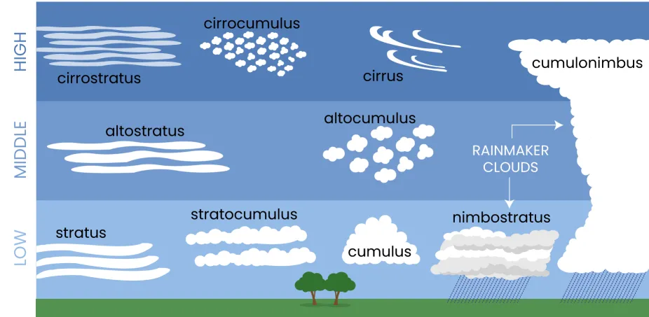
2. Classification by Altitude
The atmosphere is divided into three “etages” or levels. The height of these levels varies slightly depending on whether you are at the poles or the equator.
High-Level Clouds (Above 20,000 ft / 6,000 m)
These clouds are so high and cold that they are made entirely of ice crystals. They usually have the prefix “Cirro-“.
- Cirrus: Delicate, wispy streaks.
- Cirrocumulus: Small, white ripples (looks like fish scales).
- Cirrostratus: A thin veil that often creates a “halo” around the sun or moon.
Mid-Level Clouds (6,500 to 20,000 ft / 2,000–6,000 m)
These clouds are made of a mix of water droplets and ice crystals. They use the prefix “Alto-“.
- Altocumulus: Gray or white patches or round masses.
- Altostratus: A gray/blue sheet that makes the sun look “watery” or blurred, like looking through frosted glass.
Low-Level Clouds (Below 6,500 ft / 2,000 m)
These are mostly made of liquid water droplets.
- Stratus: Low-hanging gray blankets (if they touch the ground, they are fog).
- Stratocumulus: Low, lumpy, grayish-white layers with some space between the “clumps.”
- Nimbostratus: Thick, dark gray layers that produce steady, continuous rain or snow.
3. Vertical Growth Clouds
Some clouds don’t stay in one layer; they grow upward through multiple levels.
- Cumulus: Small “fair-weather” clouds.
- Cumulonimbus: When a cumulus cloud gets enough energy, it grows into a massive, anvil-shaped tower. These are the “kings of clouds,” responsible for lightning, thunder, and heavy storms.
Summary Table
| Altitude | Prefix | Cloud Types |
| High | Cirro- | Cirrus, Cirrostratus, Cirrocumulus |
| Middle | Alto- | Altostratus, Altocumulus |
| Low | (None) | Stratus, Stratocumulus, Nimbostratus |
| Vertical | (None) | Cumulus, Cumulonimbus |
What are cloud ceilings and how are they measured?
In aviation and meteorology, a cloud ceiling is defined as the height above the Earth’s surface to the base of the lowest layer of clouds that is reported as “broken” or “overcast.”
It is essentially the “floor” of the clouds. If the sky is only partially covered (like a few scattered cotton balls), scientists don’t consider it a ceiling because a pilot could still see the ground or fly through the gaps.
1. How Ceilings are Classified
Meteorologists measure how much of the sky is covered in “oktas” (eighths). A ceiling only exists if more than half of the sky is obscured:
- Few/Scattered (1/8 to 4/8 coverage): No ceiling.
- Broken (5/8 to 7/8 coverage): This constitutes a ceiling.
- Overcast (8/8 coverage): This constitutes a ceiling.
2. How are Cloud Ceilings Measured?
Measuring a cloud’s height by eye is notoriously difficult, so scientists use specialized technology to get an exact reading.
The Ceilometer (Modern Standard)
The most common tool today is a laser ceilometer. It works on the principle of LIDAR (Light Detection and Ranging).
- The device sends a pulse of laser light straight up into the sky.
- The light hits the base of the cloud and reflects back down.
- The device measures exactly how long it took for the light to return.
- Using the speed of light, it calculates the distance: Height = (c * t) / 2 (where c is the speed of light and t is the round-trip time).
Automated Surface Observing Systems (ASOS)
Most airports have an ASOS suite that includes a ceilometer. Because the laser only points at one spot, the system tracks the clouds as they drift over the sensor over a 30-minute period to create an average “map” of the ceiling height for the whole area.
Weather Balloons (Radiosondes)
In some cases, scientists launch balloons equipped with sensors. As the balloon rises, it measures humidity. A sudden jump to 100% humidity usually indicates the balloon has entered the cloud base, providing a vertical profile of the ceiling.
3. Why It Matters
- Aviation Safety: Pilots need to know the ceiling to determine if they can land using visual cues or if they must rely entirely on instruments. If the ceiling is too low (e.g., below 200 feet), many aircraft are grounded.
- Weather Forecasting: A dropping ceiling often indicates an approaching warm front and impending rain.
- Energy: For solar power plants, the ceiling height and density determine how much “diffuse” light will reach the panels versus direct sunlight.
Vertical Visibility (VV)
Sometimes, the air is so thick with fog, snow, or smoke that you can’t see the “base” of a cloud at all. In these cases, meteorologists report Vertical Visibility. This is the distance a person can see upward into the “indefinite ceiling” of the obstruction.
What are weather satellites?
Weather satellites are sophisticated “eyes in the sky” that orbit the Earth, equipped with sensors to monitor the atmosphere, oceans, and land. Unlike a standard telescope that looks at stars, these satellites look back at Earth to track cloud patterns, temperature, wind speeds, and moisture levels.
They are the backbone of modern meteorology. Without them, we would have very little warning for hurricanes, blizzards, or severe thunderstorms.
How They Work: The “Invisible” View
Weather satellites don’t just take “photos” like a regular camera. They use radiometers to measure electromagnetic radiation. This allows them to see things the human eye cannot:+1
- Visible Imagery: Shows clouds and textures exactly as they would look to a human. This is great for tracking storms during the day.
- Infrared (IR) Imagery: Measures heat. Since clouds are colder than the Earth’s surface, IR allows satellites to “see” clouds at night. It also tells us how tall a cloud is—the colder the cloud top, the higher and more dangerous the storm.
- Water Vapor Imagery: Detects moisture in the upper atmosphere, even when there are no clouds present. This helps meteorologists see the “invisible” rivers of air that steer weather systems.
The Two Main Types of Weather Satellites
Scientists use two different “orbits” to get a full picture of the Earth’s weather.
1. Geostationary Satellites (GEO)
These sit very high up—about 35,800 kilometers (22,300 miles)—above the equator. They orbit at the exact same speed that the Earth rotates, so they stay “parked” over the same spot 24/7.
- Use Case: Providing constant “movies” of weather moving across a continent. They are perfect for tracking the real-time development of a tornado or the path of a hurricane.
- Famous Examples: The GOES (Geostationary Operational Environmental Satellite) series used by the US.
2. Polar-Orbiting Satellites (POES)
These orbit much closer to Earth—about 850 kilometers (530 miles). They fly from pole to pole, and as the Earth turns underneath them, they eventually scan the entire globe, piece by piece.
- Use Case: Providing incredibly high-resolution, detailed data. Because they are closer, they can measure temperature and humidity at different “slices” of the atmosphere, which is vital for long-term computer weather models.
- Famous Examples: The JPSS (Joint Polar Satellite System).
What Do They Actually Measure?
While tracking clouds is their most famous job, weather satellites also collect data on:
- Sea Surface Temperatures: Crucial for predicting El Niño and hurricane intensity.
- Vegetation Health: Monitoring droughts and forest fire risks.
- Ash and Dust: Tracking volcanic eruptions and Saharan dust plumes.
- Lightning: Modern satellites have “lightning mappers” that can detect flashes even inside thick clouds.
Why Are They Important?
Before satellites, we relied on ships and weather balloons. If a hurricane formed in the middle of the Atlantic, we might not know it existed until it hit a ship or made landfall. Today, we can track a storm from the moment it is a tiny cluster of clouds off the coast of Africa.
Do satellites do more than just observe clouds?
Yes, tracking clouds is actually just the “tip of the iceberg.” Modern weather satellites are essentially flying laboratories that measure energy, chemistry, and physics across the entire planet.
While our eyes see clouds, satellite sensors (radiometers) see the Earth in dozens of different “colors” or wavelengths, allowing them to monitor everything from the health of a leaf to the temperature of the deep ocean.
1. Ocean and Water Monitoring
The oceans are the “engine room” of global weather, and satellites are our primary way of monitoring them.
- Sea Surface Temperature (SST): By measuring infrared radiation from the water’s surface, satellites can identify warm patches that fuel hurricanes or detect the onset of El Niño events.
- Sea Level Rise: Using radar altimeters, satellites can measure the height of the ocean surface with sub-centimeter accuracy to track global sea-level rise.
- Ocean Color (Phytoplankton): Satellites can detect the “greenness” of the ocean, which tells scientists where microscopic algae are blooming. This is the foundation of the marine food chain.
2. Land and Vegetation Health
Satellites can tell us how “stressed” a forest or farm is before it even turns brown to the naked eye.
- NDVI (Vegetation Index): By comparing visible red light and near-infrared light, satellites measure how much photosynthesis is happening. This helps predict crop failures and droughts.+1
- Soil Moisture: Some satellites use microwave sensors to “see” through clouds and even the top layer of soil to determine how much water is available for plants.
3. Fire and Air Quality
Satellites are the “smoke detectors” of the planet.
- Fire Detection: Infrared sensors can pick up “thermal anomalies” (hot spots). This allows authorities to find forest fires in remote areas within minutes of them starting.
- Smoke and Dust Tracking: Satellites track the movement of Saharan dust across the Atlantic or smoke from wildfires as it travels across continents.
- Trace Gases: They measure pollutants like Nitrogen Dioxide (NO2) from cars and factories, as well as Sulfur Dioxide (SO2) and ash from volcanic eruptions.
4. Space Weather
Many weather satellites don’t just look down—they also look up.
- The Solar Wind: They monitor the sun for “Coronal Mass Ejections” (solar flares). This “Space Weather” can knock out power grids, disrupt GPS, and damage other satellites if we don’t have early warning to put systems into “safe mode.”
5. Search and Rescue (GEOSAR)
Almost all geostationary weather satellites carry a specialized transponder. When an emergency beacon is activated by a downed plane or a hiker in distress, the weather satellite picks up the signal and relays the exact coordinates to search and rescue teams.
Summary of Satellite Capabilities
| Feature | Sensor Type | Benefit |
| Ocean Heat | Thermal Infrared | Predicts Hurricane intensity |
| Vegetation | Near-Infrared | Detects Droughts and Famines |
| Lightning | Optical Geostationary Mapper | Warns of severe thunderstorm growth |
| Air Chemistry | Ultraviolet/Visible | Monitors Urban Smog and Volcanic Ash |
| Ice Cover | Microwave/Radar | Tracks Polar Ice Melting |
Solved Problems
Phase Changes & Moisture
1. Problem: On a humid summer day, why does a glass of ice water “sweat” on the outside, but a cup of hot coffee does not?
Solution: The cold glass chills the thin layer of air touching it to its dew point. The invisible water vapor in that air condenses into liquid droplets. The coffee cup warms the air around it, increasing its capacity to hold moisture, so no condensation occurs.
2. Problem: Why is “frozen dew” distinct from “frost”?
Solution: Frozen dew starts as liquid water droplets that freeze when the temperature drops. Frost skips the liquid stage entirely; water vapor turns directly into ice crystals through deposition because the air’s “frost point” is below freezing.
3. Problem: Why does your skin feel much colder when you step out of a pool on a windy day compared to a calm day?
Solution: The wind increases the rate of evaporation. Evaporation is a cooling process because the fastest-moving (hottest) molecules leave the liquid first, taking their energy with them and leaving the cooler molecules behind on your skin.
Fog & Visibility
4. Problem: Why can you often see thick fog in a valley while the surrounding hilltops are perfectly clear?
Solution: Cold air is denser than warm air. At night, as the ground cools, the chilled air “drains” into the lowest points of the landscape like water, reaching its dew point in the valley first.
5. Problem: Why does “steam fog” form over a lake in the late autumn but rarely in the early summer?
Solution: In autumn, the water is still warm from summer, but the air has become freezing. The warm water evaporates into the cold air and immediately saturates it. In early summer, the water is usually colder than the air, which prevents this mixing.
6. Problem: If you are driving through a “dry haze,” why do colors look muted and the horizon looks bluish?
Solution: Small particles like smoke or salt scatter shorter (blue) wavelengths of light more effectively. This scattered light creates a “veil” that reduces the contrast and color saturation of distant objects.
Cloud Mechanics
7. Problem: Why are clouds usually flat on the bottom but puffy and irregular on the top?
Solution: The flat bottom marks the Lifting Condensation Level—the exact altitude where the rising air has cooled enough to reach $100\%$ humidity. Below that line, the air is too warm for droplets to form.
8. Problem: Why does a dark storm cloud look dark if it is made of the same clear water and white ice as a light cloud?
Solution: It is a matter of density and depth. The cloud is so thick and full of large droplets that it absorbs and scatters sunlight before the light can reach the bottom. You are essentially standing in the cloud’s own shadow.
9. Problem: Why do “Cirrus” clouds look like wispy hair while “Cumulus” clouds look like solid cotton?
Solution: Cirrus clouds form at extreme altitudes where it is so cold that they are made of ice crystals, which are easily blown into long streaks by high-altitude winds. Cumulus clouds are lower and made of liquid droplets, which clump together in denser, more defined shapes.
Satellite & Remote Sensing
10. Problem: How can a weather satellite “see” a hurricane at midnight when there is no sunlight to reflect off the clouds?
Solution: The satellite uses Infrared (IR) sensors. These detect heat rather than light. Since the tops of the hurricane clouds are much colder than the ocean surface, they show up clearly on a heat map.
11. Problem: Why do meteorologists use “Water Vapor” imagery to track wind patterns even in areas where there are zero clouds?
Solution: Water vapor sensors detect moisture in the middle and upper atmosphere that hasn’t condensed into clouds yet. This allows them to see the “invisible” jet streams and currents that push weather systems around.
12. Problem: How can a satellite tell the difference between a forest fire and a bright, hot desert?
Solution: Fires emit specific “shortwave infrared” radiation that is much more intense than the solar heat reflected by a desert. Satellites look for these specific “hot spots” to trigger fire alerts.
Geographic Weather Phenomena
13. Problem: Why are the “Headlands” on a coast often foggier than the nearby sandy beaches?
Solution: Headlands force moist ocean air to rise abruptly. This rising air expands and cools (orographic lift), reaching its dew point more quickly than the air sitting over the flat beach.
14. Problem: Why is the “Grand Banks” of Newfoundland considered the foggiest place on Earth?
Solution: It is the collision point of the warm Gulf Stream and the freezing Labrador Current. The warm, moist air from the Gulf Stream is “chilled from below” by the Labrador water, creating near-constant advection fog.
15. Problem: Why does “Upslope Fog” often result in clear skies once the wind stops?
Solution: Upslope fog is maintained by the mechanical “push” of the wind. Once the wind stops, the air no longer rises and cools; it settles and warms up slightly, causing the fog to re-evaporate into invisible vapor.