In geology, rock deformation occurs when tectonic forces apply stress to the Earth’s crust. Depending on the temperature, pressure, and type of rock, the crust will either bend (ductile deformation)1 or break (brittle deformation).2
1. Folds: Bending the Earth
Folds occur when rock layers are subjected to compressional stress (pushed together) while they are deep enough—and warm enough—to behave like plastic or putty. Instead of snapping, the layers “buckle” or warp.3
Anticlines: These are arch-like folds where the layers curve upward.4 If you look at an eroded anticline from above, the oldest rocks are found in the center.5
Synclines: These are trough-like folds where the layers curve downward (like a “U”).6 In these, the youngest rocks are at the center.7
Monoclines: These are simple, step-like folds in otherwise horizontal layers, often caused by a fault deep underground that didn’t quite reach the surface.8
2. Faults: Breaking the Earth
Faults are fractures in the crust where there has been significant movement between the two sides.9 They typically occur in the upper crust where rocks are colder and more brittle.
Fault Type
Movement
Tectonic Stress
Normal Fault
The “hanging wall” (block above) slides down.
Tension (Pulling apart)
Reverse Fault
The “hanging wall” slides up.
Compression (Pushing together)
Strike-Slip Fault
Blocks slide horizontally past each other.
Shear (Sideways sliding)10
Pro-Tip: If the angle of a reverse fault is very shallow (less than 45°), it is called a thrust fault.11 These are common in massive mountain ranges like the Himalayas.
3. Other Ways to Interpret Deformation
While folds and faults are the “big two,” geologists use several other structures to interpret how the Earth has moved:
Joints (Fractures without Movement)
Unlike faults, joints are cracks in the rock where no sliding has occurred. They often form in regular patterns (sets) due to the cooling of lava or the expansion of rock as it reaches the surface. They are vital for understanding the history of regional stress.
Shear Zones
Think of a shear zone as a “ductile fault.” Deep in the crust, where it’s too hot for rocks to snap into a fault, they might deform into a narrow zone of highly stretched, smeared-out rock.12 These zones can be miles wide and act as the deep-earth equivalent of plate boundaries.
Foliation and Lineation
In metamorphic rocks, deformation can be seen at the mineral level.13
Foliation: The alignment of flat minerals (like mica) into parallel layers due to pressure.14
Lineation: The stretching of minerals into long, rod-like shapes, showing the exact direction the rock was pulled.15
Unconformities
While not a “structure” made by a single squeeze, an angular unconformity tells a story of deformation. It occurs when older rock layers are tilted or folded, eroded flat, and then new layers are deposited on top. It’s a “missing” piece of time that proves deformation happened in the past.
Would you like me to explain how geologists use “strike and dip” measurements to map these structures on a flat surface?
Visualizing Geological Structures
This video provides a clear visual breakdown of how different types of faults and folds form and how to identify them in the field.
How do geologist interpret field data?
Geologists act like “Earth detectives.” They take messy, incomplete observations from the surface and use them to reconstruct a complex, 3D history of what happened underground millions of years ago.
Here is how they move from raw field data to a complete geological interpretation.
1. Orientation: Strike and Dip
The most fundamental tool for interpreting deformation is the strike and dip measurement.1 This allows geologists to take a 3D tilted rock layer and describe its orientation with just two numbers.2
Strike: The compass direction of a horizontal line on the surface of a tilted rock bed.3 Imagine a flood filling a room; the “waterline” against the tilted floor would be the strike.
Dip: The angle at which the rock layer slopes downward from the horizontal.4 It is always measured perpendicular to the strike.5
2. Mapping Symbols
Once measurements are taken, they are plotted on a map using specific symbols.6 These symbols act as a “shorthand” that allows anyone to see the 3D structure of the earth at a glance.
Feature
Map Symbol Description
What it tells the Geologist
Bedding
A “T” shape with a number.
The long bar is the strike, the short tick is the dip direction, and the number is the dip angle.
Anticline
A line with arrows pointing away from the center.
The rock layers are arching upward; the center holds the oldest rocks.
Syncline
A line with arrows pointing toward the center.
The rock layers are curving downward; the center holds the youngest rocks.
Faults
A thick line, often with a “U” (Up) or “D” (Down).
Shows where the crust has snapped; the symbols tell which side moved.
3. The Three Stages of Interpretation
Geologists don’t just look at one rock; they synthesize data through these steps:
A. Systematic Observation (The “What”)
Geologists use a Brunton Compass to measure orientations and a loupe (magnifying glass) to identify minerals.7 They record lithology (rock type), fossils (to determine age), and contacts (where one rock type ends and another begins).8
B. Geometric Reconstruction (The “Where”)
Using the strike and dip points collected across a landscape, geologists “connect the dots.”9 If the dip symbols on either side of a valley point toward each other, they know they are standing in a syncline (a U-shaped fold), even if the middle part of the fold has been eroded away.
C. Cross-Sections (The “How”)
The final step is often creating a Geological Cross-Section.10 This is a vertical “slice” into the Earth, showing what the layers would look like if you cut a giant trench through the ground.11 This reveals the true scale of the folding and faulting.
Indirect Evidence
When rocks are covered by soil or forest, geologists look for “clues”:12
Vegetation: Certain plants prefer specific rocks (e.g., some wildflowers only grow on limestone).
Topography: Hard rocks like quartzite form ridges, while soft rocks like shale form valleys.
Remote Sensing: Using LiDAR or satellite imagery to see “through” trees to find hidden fault lines.
How do rocks become deformed?
Rocks become deformed when they are subjected to stress—forces like squeezing, pulling, or twisting—that causes them to change shape or size (a process called strain).1
Whether a rock bends into a fold or snaps into a fault depends on a combination of the type of stress applied and the physical environment the rock is in.2
1. The Three Stages of Deformation
When stress is applied to a rock, it typically moves through three distinct stages:3
Elastic Deformation: The rock stretches or compresses like a rubber band.4 If the stress is removed, the rock returns to its original shape.5
Ductile (Plastic) Deformation: The rock reaches its “elastic limit” and begins to bend or flow permanently.6 It will not go back to its original shape even if the stress stops.7 This creates folds.8
Brittle Deformation (Fracture): If the stress exceeds the rock’s strength, it snaps.9 This creates faults and joints.10
2. The Type of Stress (The “How”)
The way a rock deforms is largely dictated by the direction of the force, usually caused by the movement of tectonic plates:
Type of Stress
Direction of Force
Resulting Structure
Compression
Squeezing together
Folds or Reverse Faults
Tension
Pulling apart
Thinning or Normal Faults
Shear11
Sliding past sideways12
Strike-Slip Faults13
3. Key Factors: Why do some rocks bend while others break?
Several environmental “controls” determine if a rock will behave like glass (brittle) or like putty (ductile):
Temperature: Heat makes rocks more flexible. Deep in the crust, where it is hot, rocks tend to fold.14 Near the surface, where it is cold, they tend to fault.15
Confining Pressure: High pressure from the weight of overlying rocks “squeezes” the rock from all sides, making it harder for the rock to crack and more likely to flow.16
Strain Rate (Time): If you hit a rock with a hammer (fast stress), it shatters.17 If you apply that same force over millions of years (slow stress), the rock has time to rearrange its atoms and flow into a fold.
Rock Composition: Some minerals are naturally “softer.”18Halite (salt) and shale flow easily, while quartzite and granite are very strong and brittle.
The Brittle-Ductile Transition: There is a specific depth in the Earth’s crust (usually around 15 km) where the temperature and pressure become high enough that rocks stop breaking and start flowing.19 Most earthquakes occur above this line because that is where the rocks are still brittle enough to snap.
What are folds and what do they represent?
In geology, folds are bends or curves in rock layers that were originally flat and horizontal. They represent a permanent change in the shape of the Earth’s crust caused by tectonic forces.
What are Folds?
Folds occur when rock is subjected to ductile (plastic) deformation. Instead of snapping like a dry twig (which creates a fault), the rock behaves more like warm putty or a stack of paper, buckling into wave-like structures. This typically happens deep underground where higher temperatures and pressures make rocks more flexible.
Anticlines: Arch-shaped folds where the layers curve upward. If you were to walk across an eroded anticline, you would find the oldest rocks at the center.
Synclines: Trough-shaped folds where the layers curve downward. In these, the youngest rocks are found at the center.
Monoclines: Single, step-like bends in otherwise horizontal rock layers.
What do Folds Represent?
Folds are essentially “frozen motion”—they act as a physical record of the Earth’s history. Here is what they represent to a geologist:
1. Compressional Stress
Most folds are a direct result of shortening. They represent a time when the Earth’s crust was squeezed together, usually by the collision of tectonic plates. Just as a rug bunches up when you push it against a wall, the crust folds to accommodate being pushed into a smaller space.
2. Ancient Mountain Building (Orogeny)
Large-scale “fold belts” (like those found in the Appalachians or the Alps) represent massive mountain-building events. These folds show where continents once collided, even if the mountains themselves have since eroded away.
3. Depth and Temperature Conditions
Because rocks are brittle near the surface, the presence of folds suggests that the deformation likely occurred at significant depth (often several kilometers down), where the Earth’s internal heat allowed the rock to flow without breaking.
4. Economic Potential
Folds represent major “traps” for natural resources.
Oil and Gas: Petroleum often migrates upward through porous rock until it gets stuck in the arch of an anticline, creating a reservoir.
Minerals: Precious metals like gold are often found in “saddle reefs”—the gaps created between layers during the folding process.
Summary: A fold is more than just a bent rock; it is a 3D map showing exactly how much a region was squeezed, which direction the pressure came from, and how deep the rocks were when it happened.
Geological Folds Explained This video provides a visual introduction to how crustal deformation creates different types of folds and explains their significance in structural geology.
How does a rock fracture and what are joints and faults?
When the Earth’s crust is cool and under high stress, it doesn’t bend—it breaks.1 This process is called brittle deformation.2
How Rocks Fracture
A rock fractures when the stress applied to it (the force) exceeds the rock’s internal strength.3 Think of it like a piece of glass: it can handle a little pressure, but once you cross a certain threshold, a crack instantly “nucleates” at a weak point and zips through the material.
Stress Concentration: Stress isn’t spread evenly.4 It concentrates at microscopic flaws—like a tiny air bubble or a sharp mineral grain—acting like the “start” of a tear in a bag.
Bond Breaking: On an atomic level, the stress pulls the atoms apart until their chemical bonds literally snap.
Propagation: Once a crack starts, the stress at the very tip of that crack becomes enormous, causing it to “run away” through the rock until the energy is spent.
Joints vs. Faults
While both are fractures, geologists distinguish them based on movement.
1. Joints: Cracks without Movement5
Joints are fractures where the rock has pulled apart slightly but has not slid past the other side.6 They are the most common geological structure on Earth.
Why they form: They often occur when rocks expand as they are brought to the surface (unloading) or when lava cools and shrinks (cooling).7
Appearance: They usually appear in “sets”—a series of parallel cracks that look like someone sliced the rock with a giant knife.8
Significance: Joints are vital for civil engineering (they are planes of weakness) and for finding water, as they act as underground “pipes” for groundwater.9
2. Faults: Cracks with Movement
A fault is a fracture where the two blocks of rock have visibly slid past one another.10 This sliding can be inches or hundreds of miles.
Why they form: Large-scale tectonic forces (pushing, pulling, or sliding) force the crust to move.11
The Energy Release: Because faults are rough, they often “stick.” When they finally slip, the sudden release of stored energy is what causes an earthquake.
Key Types: * Normal: Pulled apart (tension).12
Reverse: Pushed together (compression).
Strike-Slip: Slid sideways (shear).
Comparison at a Glance
Feature
Joints
Faults
Movement
No sliding; just a gap.
Visible sliding/offset.
Tectonic Cause
Cooling, unloading, or light tension.
Significant tectonic stress.
Seismic Activity
Generally quiet.
Source of earthquakes.
Patterns13
Often form regular, parallel “sets.”14
Usually singular lines or complex “zones.”
How do geologists unravel geologic history?
To unravel the history of our planet, geologists use a combination of relative dating (determining the order of events) and absolute dating (determining the actual numerical age).1 By combining these two, they can turn a chaotic rock outcrop into a chronological story.
1. Relative Dating: The Laws of the Earth
Geologists follow a set of “logic rules” called the Laws of Stratigraphy to figure out which event happened first.
Law of Superposition: In an undisturbed sequence of rocks, the oldest layers are at the bottom and the youngest are at the top.2 Think of it like a stack of newspapers; the one on the bottom was delivered first.3
Principle of Original Horizontality: Sedimentary layers are originally deposited flat.4 If you see them tilted or folded, you know a tectonic event happened after they were formed.5
Principle of Cross-Cutting Relationships: Any feature that cuts through a rock (like a fault or an igneous intrusion) must be younger than the rock it cuts.6 You can’t cut a cake unless the cake already exists.
Principle of Inclusions: If a rock contains fragments of another rock inside it, those fragments (inclusions) must be older than the rock surrounding them.7
2. Paleontology: The Biological Clock
Because life on Earth has evolved in a specific order, fossils act as “time stamps” for rock layers.8
Faunal Succession: Geologists have mapped the appearance and disappearance of species over millions of years.9
Index Fossils: These are specific fossils (like Trilobites or Ammonites) that lived for a very short time but were found all over the world.10 Finding one instantly tells a geologist exactly which “chapter” of Earth’s history they are looking at.
3. Absolute Dating: The Atomic Clock
While relative dating tells us the order, Radiometric Dating tells us the years. This relies on the steady decay of radioactive isotopes trapped inside minerals.
Method
Parent Isotope
Half-Life
Best Used For
Carbon-14
Carbon-14
~5,730 years
Archeology and young organic material.
Potassium-Argon
Potassium-40
1.3 billion years
Volcanic ash and very old igneous rocks.
Uranium-Lead
Uranium-238
4.5 billion years
The oldest rocks on Earth and the Solar System.
4. Synthesis: Putting it Together
A geologist starts in the field by mapping the structures (folds/faults) and measuring their orientations. Back in the lab, they date the rocks using isotopes and fossils.11 By layering these pieces of evidence, they can say, for example: “First, this area was a shallow sea (fossils), then it was squeezed into mountains (folding), and finally, it was split by a volcanic eruption (cross-cutting) 60 million years ago (radiometric dating).”
Would you like to try interpreting a sample “geologic puzzle” to see if you can put the events in the correct order?
Unraveling Earth’s Geological History
This video explains the principles of stratigraphy and biostratigraphy, showing how geologists use fossils and rock layers to build the global geologic timescale.
How do landforms express deformation?
Landforms are the surface “symptoms” of the deep deformation happening underground. Because different types of rock and structures erode at different rates, the landscape often acts as a 3D blueprint of the hidden folds and faults.
1. Topographic Expression of Folds
Folds rarely stay as simple wave-shaped hills. Over millions of years, erosion reshapes them into distinct patterns.
Ridges and Valleys: In a “fold and thrust” belt (like the Appalachians), hard, resistant rocks like sandstone form long, linear ridges, while softer rocks like shale erode into parallel valleys.
Anticlinal Valleys vs. Synclinal Ridges: Paradoxically, the center of an anticline (an arch) is often under tension and cracks easily, causing it to erode into a valley. Conversely, the center of a syncline (a trough) is compressed and tightly packed, making it tougher and more likely to stand out as a high ridge or plateau.
V-Shaped Patterns: When a fold tilts (plunges) into the ground, its surface expression looks like a series of zig-zags or “V” shapes on a map.
2. Topographic Expression of Faults
Faults create sharp, geometric changes in the landscape that are often visible even from space.
Fault Scarps: A “step” in the landscape formed when one side of a fault moves vertically. If you see a sudden, steep cliff in an otherwise flat area, it’s often a fresh fault scarp.
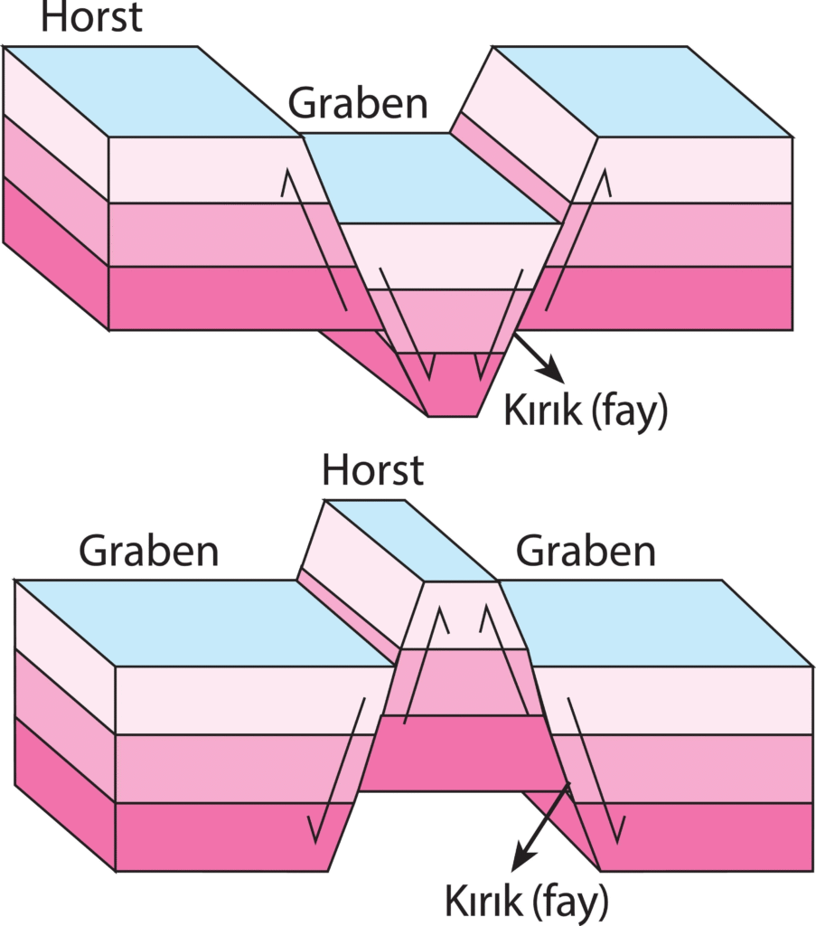
Horsts and Grabens: In areas where the crust is being pulled apart (like the Basin and Range province in Nevada), the land breaks into high blocks (horsts) that form mountains and low blocks (grabens) that form valleys.
Linear Features: Strike-slip faults (like the San Andreas) often create perfectly straight valleys or “sag ponds” (small lakes) where the ground has been ground into powder by the sliding blocks.
Offset Drainage: If you see a river that flows straight and then suddenly makes a sharp 90-degree turn before continuing, you are likely looking at a fault that has physically shifted the riverbed sideways.
3. The “Rule of V’s”
Geologists use the way rock layers interact with valley topography to “see” underground. When a tilted rock layer crosses a stream valley, its outcrop pattern forms a “V” shape.
The direction that “V” points reveals the dip (tilt) of the rock layer relative to the slope of the valley.
This allows a geologist to look at a simple topographic map and immediately know if the rocks underground are horizontal, vertical, or tilted.
4. Tectonic Geomorphology
This is the study of how active deformation currently shapes the surface. Geologists look for:
Marine Terraces: Flat “staircases” along a coast that represent former beaches being pushed out of the ocean by tectonic uplift.
Fault-Controlled Streams: Rivers that are forced to follow the weak, crushed rock along a fault line rather than taking the most direct path downhill.
Why it matters: By looking at these landforms, geologists can determine how fast a mountain range is growing or how often a fault produces an earthquake, even if the last event happened before human records began.
Solved Problems
Structural Interpretation Problems
Problem: Determining the age of layers in a “mystery” fold.
Solution: Identify if it is an anticline or syncline. In an anticline, the oldest rocks are in the core; in a syncline, the youngest are in the core.
Problem: Interpreting a rock layer that appears “upside down.”
Solution: Use the Law of Superposition and check for “up-section” indicators like fossils or cross-bedding to verify if tectonic forces have completely overturned the sequence.
Problem: Mapping a tilted rock bed hidden under a thick forest.
Solution: Utilize LiDAR to strip away vegetation and look for “V-shaped” outcrop patterns in stream valleys to determine the dip direction.
Problem: Differentiating a joint from a fault in the field.
Solution: Inspect the fracture surface for “slickensides” (polished grooves) or offset layers; if there is no visible sliding or movement, it is a joint.
Problem: Predicting where rock will bend versus where it will snap.
Solution: Analyze the depth and temperature. Above the Brittle-Ductile transition (~15km), rocks fault; below it, high heat and pressure favor folding.
Problem: Finding the source of an earthquake on a flat plain.
Solution: Look for “fault scarps” or linear features like “sag ponds” and offset river drainages that indicate a strike-slip fault.
Applied Geology & Resource Problems
Problem: Locating an oil reservoir in a folded mountain belt.
Solution: Target the crest of anticlines, which act as structural traps where migrating oil and gas accumulate under impermeable layers.
Problem: Drilling a safe tunnel through a mountain range.
Solution: Map the “joint sets” and faults to identify planes of weakness that could lead to tunnel collapse or groundwater flooding.
Problem: Finding gold in a metamorphic terrain.
Solution: Look for “saddle reefs” in the hinges of folds or mineralized “veins” where fractures allowed gold-bearing fluids to circulate.
Problem: Assessing if a mountain range is still actively growing.
Solution: Study “tectonic geomorphology,” specifically looking for uplifted marine terraces or fresh fault scarps.
Problem: Determining the direction of ancient tectonic plate movement.
Solution: Measure the strike and dip of multiple folds; the direction of the “fold axis” is generally perpendicular to the direction of the compressional stress.
Historical & Chronological Problems
Problem: Dating a mountain-building event with no direct fossils.
Solution: Use the Principle of Cross-Cutting Relationships. If a 100-million-year-old granite dike cuts across a fold, the folding must be older than 100 million years.
Problem: Explaining a “gap” in the geological record (an unconformity).
Solution: Interpret the sequence as a period of uplift and deformation followed by erosion, and finally, the deposition of new layers on top.
Problem: Identifying the precise numerical age of a fold.
Solution: Use Radiometric Dating (like Uranium-Lead) on crystals in volcanic ash layers found directly above or below the deformed sequence.
Problem: Reconstructing a “shattered” landscape with dozens of faults.
Solution: Create a geological cross-section (a vertical “slice”) to visualize how the blocks originally fit together before faulting.
Physical & Chemical Mechanics
Problem: Explaining why a strong rock like granite behaves like plastic.
Solution: Factor in the “Strain Rate.” Over millions of years, even the hardest rock can flow if the stress is applied slowly enough.
Problem: Understanding why some faults are “shallow” while others are “steep.”
Solution: Identify the stress type. Tension (Normal faults) creates steep angles, while Compression (Thrust faults) often creates very shallow, low-angle breaks.
Problem: Determining if a rock was “stretched” or “squeezed” at the mineral level.
Solution: Examine the rock for foliation (squeezing) or lineation (stretching) of minerals like mica or quartz.